IMAGES TAKEN NEAR TO
Risca, NEWPORT, NP11 6HA
Introduction
This page details the photographs taken nearby to NP11 6HA by members of the Geograph project.
The Geograph project started in 2005 with the aim of publishing, organising and preserving representative images for every square kilometre of Great Britain, Ireland and the Isle of Man.

There are currently over 7.5m images from over14,400 individuals and you can help contribute to the project by visiting https://www.geograph.org.uk
Image Map
Images are licensed for reuse under creativecommons.org/licenses/by-sa/2.0
Notes
- Clicking on the map will re-center to the selected point.
- The higher the marker number, the further away the image location is from the centre of the postcode.
Image Listing (72 Images Found)
Images are licensed for reuse under creativecommons.org/licenses/by-sa/2.0
Image
Details
Distance
1
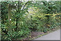
Footpath, Raven Walk, from canal towpath
Top of steps from towpath/cycle route 465 down towards path Image to Medart Street. The bilingual sign says, 'Waunfawr Park'.
Image: © M J Roscoe
Taken: 2 Nov 2017
0.01 miles
2
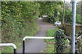
Track near Monmouthshire & Brecon Canal
Track alongside the canal (just out of sight to left) is part of National Cycle Route 47. The track becomes a path on the camera side of the metal barrier.
Image: © M J Roscoe
Taken: 20 Oct 2017
0.02 miles
3
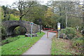
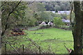
Approaching Green Meadow Bridge from the west
The Raven Walk runs along the towpath and turns left crossing the grade II listed bridge Image over the Monmouthshire & Brecon Canal. National cycle route 465 starts at the red barrier (from route 47) and runs towards the camera. Beyond the red gate is cycle route 47 which joins the towpath from the right here. Twelve years ago there were no barriers or signposts Image
Image: © M J Roscoe
Taken: 2 Nov 2017
0.03 miles
4
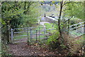
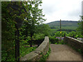
Kissing gate near Monmouthshire & Brecon Canal
The Raven Walk goes through the gate and across the arched Green Meadow Bridge 17 Image over the canal's Crumlin Arm.
Image: © M J Roscoe
Taken: 20 Oct 2017
0.03 miles
5
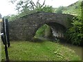
Green Meadow Bridge over Monmouthshire & Brecon Canal
The Raven Walk runs past the field gate, across the arched Green Meadow Bridge Image over the canal's Crumlin Arm and turns right on to the towpath.
Image: © M J Roscoe
Taken: 20 Oct 2017
0.03 miles
6
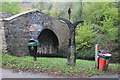
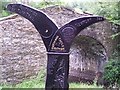
Green Meadow Bridge 17 Monmouthshire & Brecon Canal
The arched bridge carries part of the Raven Walk over to Cwm Bir. the diamond sign has information about the burial ground Image in a field on the far side of the bridge. The left arm on the National Cycle Route 47 mile post reads, '17 1/4 m Pontypridd 11 3/4 m Taff Trail', the right arm, 'Newport 7 1/2 m'.
Image: © M J Roscoe
Taken: 20 Oct 2017
0.04 miles
7
Footbridge to Cwmbyr Farm over Monmouthshire and Brecon Canal
Image: © David Smith
Taken: 25 Sep 2021
0.04 miles
8
Weight limit, MonBrec Crumlin Arm
GWR weight limit sign, dating from between 1880 & 1947.
Milestone Society ID: TBC
Image: © Mr Red
Taken: 10 Jun 2021
0.04 miles
9
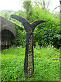
Millennium Cycle Route Fingerpost
Fingerpost - Route 47 see https://www.sustrans.org.uk/find-a-route-on-the-national-cycle-network/route-47/ . Alternative views see http://www.geograph.org.uk/photo/5579841 & https://www.geograph.org.uk/photo/55554
Inscription: 17¼ M Pontypridd / 11¾ M Taff Trail // Newport 7½ M
Millennium Time Trail ID: MP247.
Image: © Mr Red
Taken: 10 Jun 2021
0.05 miles
10
National Cycle Trail sign, Risca, Caerphilly
Most of the towpath of the Monmouth & Brecon Canal south of Risca has been utilised by Sustrans for the National Cycle Network. This is the signpost at an overbridge where NCN 47 (linking the Taff Trail to Newport) joins the Canal.
Image: © Ralph Rawlinson
Taken: 29 Aug 2005
0.06 miles