IMAGES TAKEN NEAR TO
Church Road Terrace, NEWPORT, NP11 6GT
Introduction
This page details the photographs taken nearby to Church Road Terrace, NP11 6GT by members of the Geograph project.
The Geograph project started in 2005 with the aim of publishing, organising and preserving representative images for every square kilometre of Great Britain, Ireland and the Isle of Man.

There are currently over 7.5m images from over14,400 individuals and you can help contribute to the project by visiting https://www.geograph.org.uk
Image Map
Images are licensed for reuse under creativecommons.org/licenses/by-sa/2.0
Notes
- Clicking on the map will re-center to the selected point.
- The higher the marker number, the further away the image location is from the centre of the postcode.
Image Listing (160 Images Found)
Images are licensed for reuse under creativecommons.org/licenses/by-sa/2.0
Image
Details
Distance
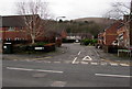
1
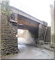
Steps to Sarn Place, Risca
On the NE side of a railway bridge, http://www.geograph.org.uk/photo/2238570 steps lead up from Church Road to houses in Sarn Place. http://www.geograph.org.uk/photo/2252173
Image: © Jaggery
Taken: 17 Jan 2011
0.01 miles
2
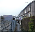
Risca : Path between Sarn Place and railway lines
The path is reached from steps http://www.geograph.org.uk/photo/2238572 from Church Road. The railway lines are part of the Ebbw Valley Railway.
Image: © Jaggery
Taken: 17 Jan 2011
0.01 miles
4
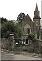
Grade II listed entrance gateway to the churchyard of St Mary Risca
Grade II listed in 1999. The Cadw website description is
Two tall gatepiers of regular tooled ashlar blocks, the angles chamfered and the top course broached to an octagon on which sits a shallow octagonal capstone. Wide and tall double iron gates with spear finials and Gothic arches reflecting the architectural style of the church.
Image: © Jaggery
Taken: 10 Jan 2017
0.03 miles
5
Cwrt Yr Ysgol, Risca
Cul-de-sac viewed across St Mary Street.
Image: © Jaggery
Taken: 10 Jan 2017
0.04 miles
6
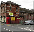
Red phonebox on a Risca corner
On the corner of St Mary Street and Grove Road, in front of the Good Buy Shop.
Image: © Jaggery
Taken: 10 Jan 2017
0.04 miles
7
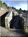
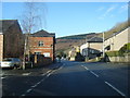
Railway embankment, Darran Road
Dives beneath the Newport to Abertillery railway, above Risca.
Image: © Roger Cornfoot
Taken: 1 Mar 2007
0.04 miles
8
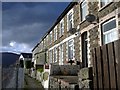
Traditional Welsh terrace, Fernlea
The railway from Newport to Abertillery runs immediately in front of these houses. The track can be glimpsed behind the wire fence, on the left.
Image: © Roger Cornfoot
Taken: 1 Mar 2007
0.04 miles
9
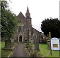
Entrance path to the Parish Church of St Mary the Virgin, Risca
From Church Road. The church is part of the Church in Wales Diocese of Monmouth.
The Cadw website records that the building dates from 1852. The site was originally occupied by a Roman building associated with the Second Legion stationed at Isca (present-day Caerleon). A post-Conquest church was erected from c1146, a daughter church of Bassaleg. In 1733 the dedication was to St Peter, later to St Michael. In the 17th century Risca was spelt Ryseley, and Rhysga a century later. In the mid 18th century services were held in Welsh, by 1813 chiefly in Welsh.
In 1839 Chartists marching to Newport passed the church, which was locked to shelter parishioners. Wealth from coal seams discovered on parish land and the creation of the separate Parish of Risca led to the decision to demolish the old church and build anew. The 1852 church was dedicated to St Mary the Virgin.
The building was Grade II listed in 1999.
Image: © Jaggery
Taken: 10 Jan 2017
0.04 miles
10
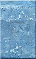
Ordnance Survey Cut Mark
This OS cut mark can be found on the porch of St Mary's Church. It marks a point 53.587m above mean sea level.
Image: © Adrian Dust
Taken: 11 May 2019
0.04 miles