IMAGES TAKEN NEAR TO
St. Mary Street, NEWPORT, NP11 6GS
Introduction
This page details the photographs taken nearby to St. Mary Street, NP11 6GS by members of the Geograph project.
The Geograph project started in 2005 with the aim of publishing, organising and preserving representative images for every square kilometre of Great Britain, Ireland and the Isle of Man.

There are currently over 7.5m images from over14,400 individuals and you can help contribute to the project by visiting https://www.geograph.org.uk
Image Map
Images are licensed for reuse under creativecommons.org/licenses/by-sa/2.0
Notes
- Clicking on the map will re-center to the selected point.
- The higher the marker number, the further away the image location is from the centre of the postcode.
Image Listing (159 Images Found)
Images are licensed for reuse under creativecommons.org/licenses/by-sa/2.0
Image
Details
Distance
1
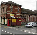
Red phonebox on a Risca corner
On the corner of St Mary Street and Grove Road, in front of the Good Buy Shop.
Image: © Jaggery
Taken: 10 Jan 2017
0.02 miles
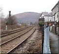
2
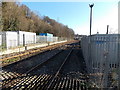
Towards Risca & Pontymister railway station from Lime Kiln level crossing, Risca
Viewed looking SE from here. http://www.geograph.org.uk/photo/1759011 The station is nearly 2km ahead.
Image: © Jaggery
Taken: 11 Jan 2014
0.02 miles
4
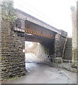
Steps to Sarn Place, Risca
On the NE side of a railway bridge, http://www.geograph.org.uk/photo/2238570 steps lead up from Church Road to houses in Sarn Place. http://www.geograph.org.uk/photo/2252173
Image: © Jaggery
Taken: 17 Jan 2011
0.04 miles
5
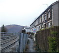
Risca : Path between Sarn Place and railway lines
The path is reached from steps http://www.geograph.org.uk/photo/2238572 from Church Road. The railway lines are part of the Ebbw Valley Railway.
Image: © Jaggery
Taken: 17 Jan 2011
0.04 miles
6
Cwrt Yr Ysgol, Risca
Cul-de-sac viewed across St Mary Street.
Image: © Jaggery
Taken: 10 Jan 2017
0.04 miles
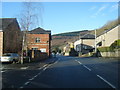
7

Houses on the corner of Church Road and St Mary Street, Risca
Church Road, at lower right, climbs away from St Mary Street.
Image: © Jaggery
Taken: 11 Mar 2010
0.05 miles
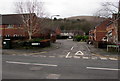
8
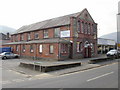
C P Bathrooms, Risca
Located on St Mary Street, next to the northern end of Grove Road.
The premises consist of a brick and stone building, probably dating from the 19th century, and a much newer extension next to it.
Sanitary ware, showers and shower enclosures, taps, radiators and accessories are on display in their showrooms, covering some 7,000 square feet.
UPDATE 2011 Premises now occupied by Ebenezers Emporium. http://www.geograph.org.uk/photo/2704736
Image: © Jaggery
Taken: 11 Mar 2010
0.05 miles
9
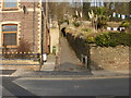
Footpath to Sarn Place, Risca
The footpath climbs away from St Mary Street towards a tunnel under the Cardiff Central to Ebbw Vale Parkway railway line.
Image: © Jaggery
Taken: 11 Mar 2010
0.05 miles
10
Sarn Place, Risca : railway lines head for Crosskeys
The view is roughly halfway between Risca & Pontymister station http://www.geograph.org.uk/photo/1749458 (behind the camera) and Crosskeys station http://www.geograph.org.uk/photo/1930137, on the Ebbw Valley Railway.
Image: © Jaggery
Taken: 17 Jan 2011
0.05 miles