IMAGES TAKEN NEAR TO
Grove Road, NEWPORT, NP11 6GL
Introduction
This page details the photographs taken nearby to Grove Road, NP11 6GL by members of the Geograph project.
The Geograph project started in 2005 with the aim of publishing, organising and preserving representative images for every square kilometre of Great Britain, Ireland and the Isle of Man.

There are currently over 7.5m images from over14,400 individuals and you can help contribute to the project by visiting https://www.geograph.org.uk
Image Map
Images are licensed for reuse under creativecommons.org/licenses/by-sa/2.0
Notes
- Clicking on the map will re-center to the selected point.
- The higher the marker number, the further away the image location is from the centre of the postcode.
Image Listing (169 Images Found)
Images are licensed for reuse under creativecommons.org/licenses/by-sa/2.0
Image
Details
Distance
1
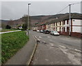
Grove Road towards Crescent Road, Risca
The grassy bank is above the Ebbw River.
Image: © Jaggery
Taken: 10 Jan 2017
0.02 miles
2

Houses on the corner of Church Road and St Mary Street, Risca
Church Road, at lower right, climbs away from St Mary Street.
Image: © Jaggery
Taken: 11 Mar 2010
0.03 miles
3
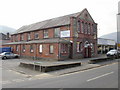
C P Bathrooms, Risca
Located on St Mary Street, next to the northern end of Grove Road.
The premises consist of a brick and stone building, probably dating from the 19th century, and a much newer extension next to it.
Sanitary ware, showers and shower enclosures, taps, radiators and accessories are on display in their showrooms, covering some 7,000 square feet.
UPDATE 2011 Premises now occupied by Ebenezers Emporium. http://www.geograph.org.uk/photo/2704736
Image: © Jaggery
Taken: 11 Mar 2010
0.03 miles
4
Footpath to Sarn Place, Risca
The footpath climbs away from St Mary Street towards a tunnel under the Cardiff Central to Ebbw Vale Parkway railway line.
Image: © Jaggery
Taken: 11 Mar 2010
0.03 miles
5
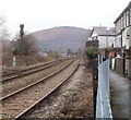
Sarn Place, Risca : railway lines head for Crosskeys
The view is roughly halfway between Risca & Pontymister station http://www.geograph.org.uk/photo/1749458 (behind the camera) and Crosskeys station http://www.geograph.org.uk/photo/1930137, on the Ebbw Valley Railway.
Image: © Jaggery
Taken: 17 Jan 2011
0.03 miles
6

Former Soar Welsh Calvinistic Methodist Chapel, Risca
A stone roundel on the dividing line between 22 and 24 St Mary Street shows SOAR in large capital letters, and the opening year (1810), of the former chapel.
At the bottom of the roundel, another year, probably 1848 (it is 184something) records the year the chapel was rebuilt. I can find no record of when the chapel closed.
Image: © Jaggery
Taken: 10 Apr 2011
0.03 miles
7
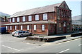
Ebenezers Emporium, Risca
Located on the corner of St Mary Street and Grove Road. Formerly C P Bathrooms. http://www.geograph.org.uk/photo/1758907
Products on sale include sanitary ware, shower enclosures, shower fittings, taps, radiators and accessories.
A stone inscription on the building shows that it was built in 1893 as a Primitive Methodist Sunday School.
Image: © Jaggery
Taken: 10 Apr 2011
0.03 miles
8
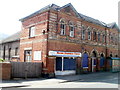
House Clearance Centre, Risca
Located on the corner of St Mary Street and Grove Road. The text below the name board shows
"New & Used Furniture, Electrical Goods, Baby Equipment Etc."
A stone inscription on the building shows RISCA PUBLIC HALL 1884.
Image: © Jaggery
Taken: 10 Apr 2011
0.03 miles
9
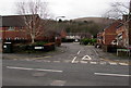
Cwrt Yr Ysgol, Risca
Cul-de-sac viewed across St Mary Street.
Image: © Jaggery
Taken: 10 Jan 2017
0.04 miles
10
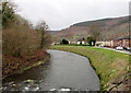
Bend in the Ebbw River, Risca
Upstream from this http://www.geograph.org.uk/photo/5250393 footbridge.
Image: © Jaggery
Taken: 10 Jan 2017
0.04 miles