IMAGES TAKEN NEAR TO
Pontymason Lane, NEWPORT, NP11 6GH
Introduction
This page details the photographs taken nearby to Pontymason Lane, NP11 6GH by members of the Geograph project.
The Geograph project started in 2005 with the aim of publishing, organising and preserving representative images for every square kilometre of Great Britain, Ireland and the Isle of Man.

There are currently over 7.5m images from over14,400 individuals and you can help contribute to the project by visiting https://www.geograph.org.uk
Image Map
Images are licensed for reuse under creativecommons.org/licenses/by-sa/2.0
Notes
- Clicking on the map will re-center to the selected point.
- The higher the marker number, the further away the image location is from the centre of the postcode.
Image Listing (55 Images Found)
Images are licensed for reuse under creativecommons.org/licenses/by-sa/2.0
Image
Details
Distance
1
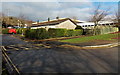
Bungalow and Royal Mail van near Pontymason Lane, Risca
Near Risca Community Comprehensive School and Risca Leisure Centre.
Image: © Jaggery
Taken: 22 Jan 2014
0.01 miles
2
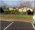
Bicycle racks near a school and leisure centre in Risca
Near Risca Community Comprehensive School and Risca Leisure Centre.
Image: © Jaggery
Taken: 22 Jan 2014
0.01 miles
3
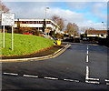
Pedestrian & cycle entrance to Risca Community Comprehensive School
From Pontymason Lane. The sign shows Pedestrian & cycle access only.
Image: © Jaggery
Taken: 22 Jan 2014
0.02 miles
4
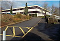
Entrance to Risca Community Comprehensive School
From Pontymason Lane.
Image: © Jaggery
Taken: 22 Jan 2014
0.03 miles
5
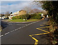
Zigzag yellow line opposite Mountside, Risca
The zigzag yellow line indicates no parking or stopping at
the western edge of Risca Community Comprehensive School (on the right).
Image: © Jaggery
Taken: 22 Jan 2014
0.03 miles
6

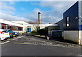
Penycae Risca electricity substation
Viewed across Pontymister Road. The identifier on the Western Power Distribution electricity substation is PENYCAE RISCA S/S No. 53-6974.
Image: © Jaggery
Taken: 22 Jan 2014
0.04 miles
7

Risca Leisure Centre entrance door
On the SE side of Risca Community Comprehensive School, Risca Leisure Centre is accessed from Pontymason Lane.
Image: © Jaggery
Taken: 22 Jan 2014
0.04 miles
8

Zebra crossing, Pontymason Lane, Risca
Near Risca Community Comprehensive School. Although Belisha beacons had marked pedestrian crossings in the UK from 1934, it was not until 1951 that the now familiar black and white stripes stretching across the width of the road were officially introduced. Previously, there were only metal studs across the road surface.
Image: © Jaggery
Taken: 22 Jan 2014
0.05 miles
9
Risca Leisure Centre
Set back from Pontymason Lane, on the SE side of Risca Community Comprehensive School.
Image: © Jaggery
Taken: 22 Jan 2014
0.05 miles
10

Pontymason Lane towards Ty-Sign, Risca
Looking NW towards the Ty-Sign area of Risca. Old metal items http://www.geograph.org.uk/photo/4242472 are outside The Oaklands.
Image: © Jaggery
Taken: 22 Jan 2014
0.05 miles