IMAGES TAKEN NEAR TO
Cwrt Yr Ysgol, NEWPORT, NP11 6GD
Introduction
This page details the photographs taken nearby to Cwrt Yr Ysgol, NP11 6GD by members of the Geograph project.
The Geograph project started in 2005 with the aim of publishing, organising and preserving representative images for every square kilometre of Great Britain, Ireland and the Isle of Man.

There are currently over 7.5m images from over14,400 individuals and you can help contribute to the project by visiting https://www.geograph.org.uk
Image Map
Images are licensed for reuse under creativecommons.org/licenses/by-sa/2.0
Notes
- Clicking on the map will re-center to the selected point.
- The higher the marker number, the further away the image location is from the centre of the postcode.
Image Listing (168 Images Found)
Images are licensed for reuse under creativecommons.org/licenses/by-sa/2.0
Image
Details
Distance
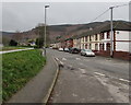
1
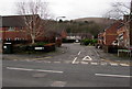
Cwrt Yr Ysgol, Risca
Cul-de-sac viewed across St Mary Street.
Image: © Jaggery
Taken: 10 Jan 2017
0.02 miles
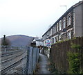
3
Steps to Sarn Place, Risca
On the NE side of a railway bridge, http://www.geograph.org.uk/photo/2238570 steps lead up from Church Road to houses in Sarn Place. http://www.geograph.org.uk/photo/2252173
Image: © Jaggery
Taken: 17 Jan 2011
0.04 miles
4
Risca : Path between Sarn Place and railway lines
The path is reached from steps http://www.geograph.org.uk/photo/2238572 from Church Road. The railway lines are part of the Ebbw Valley Railway.
Image: © Jaggery
Taken: 17 Jan 2011
0.04 miles
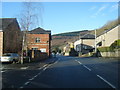
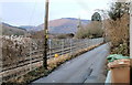
5
Grove Road towards Crescent Road, Risca
The grassy bank is above the Ebbw River.
Image: © Jaggery
Taken: 10 Jan 2017
0.04 miles
6
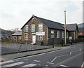
St Mary's Church Hall, Risca
Located on St Mary Street. The church http://www.geograph.org.uk/photo/1757582 is on the other side of the road.
Image: © Jaggery
Taken: 11 Mar 2010
0.04 miles
7

St Mary the Virgin church, Risca
A dilapidated old church on this site, at the corner of Church Road and St Mary Street was demolished in 1853. A new church, dedicated to St. Mary, opened for worship in 1858.
It is the Church in Wales parish church for Risca.
Image: © Jaggery
Taken: 11 Mar 2010
0.04 miles
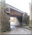
8
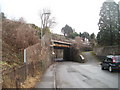
SW approach to Church Road railway bridge, Risca
The view NE along Church Road towards a railway bridge above a tight bend in the road. The 13' 3" (about 4 metres) headroom bridge carries the Ebbw Valley Railway which runs from Cardiff Central to Ebbw Vale.
Image: © Jaggery
Taken: 17 Jan 2011
0.04 miles
9
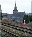
Risca : St Mary's church steeple viewed from the eastern side of Church Road
The view NW across railway lines towards the steeple of St Mary the Virgin. http://www.geograph.org.uk/photo/1757582
Image: © Jaggery
Taken: 17 Jan 2011
0.04 miles
10
Risca : St Mary's church viewed from Sarn Place
A view from the north of St Mary the Virgin church, the Church in Wales parish church for Risca.
Image: © Jaggery
Taken: 17 Jan 2011
0.04 miles