IMAGES TAKEN NEAR TO
Ochrwyth, NEWPORT, NP11 6ES
Introduction
This page details the photographs taken nearby to Ochrwyth, NP11 6ES by members of the Geograph project.
The Geograph project started in 2005 with the aim of publishing, organising and preserving representative images for every square kilometre of Great Britain, Ireland and the Isle of Man.

There are currently over 7.5m images from over14,400 individuals and you can help contribute to the project by visiting https://www.geograph.org.uk
Image Map
Images are licensed for reuse under creativecommons.org/licenses/by-sa/2.0
Notes
- Clicking on the map will re-center to the selected point.
- The higher the marker number, the further away the image location is from the centre of the postcode.
Image Listing (4 Images Found)
Images are licensed for reuse under creativecommons.org/licenses/by-sa/2.0
Image
Details
Distance
1
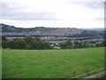
A Goml's maze
This harmless looking field near Upper Ochrwyth is the start of a maze put up by the owners of the rather posh houses on this (the south) side of the Ebbw river to divert walkers. None of the rights of way in the NE of the square is actually usable! Risca, pictured in the background, is rather less wealthy.
This square is mostly farmland, with the high ground towards Mynydd Machen (Image) in NW used as open grazing. The A467 Ebbw Vale to Newport cuts through the NE corner of the square.
Image: © Rudi Winter
Taken: 6 Aug 2005
0.08 miles
2
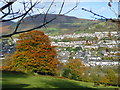
View towards Risca
Looking north across pasture towards the hill fort of Twmbarlwm.
The burnished autumn colour is that of a beech.
Image: © Jonathan Billinger
Taken: 11 Nov 2008
0.16 miles
3
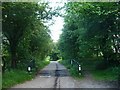
Cattle grid at the edge of Mynydd Machen Common
On the route of the Sirhowy Valley Walk.
Image: © Robin Drayton
Taken: 16 Jun 2009
0.21 miles
4
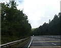
Road markings on A467 in advance of roundabout
Image: © David Smith
Taken: 27 Sep 2021
0.25 miles