IMAGES TAKEN NEAR TO
Lower Ochrwyth, NEWPORT, NP11 6EN
Introduction
This page details the photographs taken nearby to Lower Ochrwyth, NP11 6EN by members of the Geograph project.
The Geograph project started in 2005 with the aim of publishing, organising and preserving representative images for every square kilometre of Great Britain, Ireland and the Isle of Man.

There are currently over 7.5m images from over14,400 individuals and you can help contribute to the project by visiting https://www.geograph.org.uk
Image Map
Images are licensed for reuse under creativecommons.org/licenses/by-sa/2.0
Notes
- Clicking on the map will re-center to the selected point.
- The higher the marker number, the further away the image location is from the centre of the postcode.
Image Listing (24 Images Found)
Images are licensed for reuse under creativecommons.org/licenses/by-sa/2.0
Image
Details
Distance
1
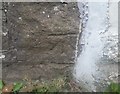
Ordnance Survey Cut Mark
This OS cut mark can be found on the former Farmers Arms. It marks a point 99.112m above mean sea level.
Image: © Adrian Dust
Taken: 11 May 2019
0.06 miles
3
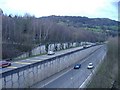
A467 approaching roundabout with B4591, Pontymister
Split level dual carriageway viewed from footbridge.
Image: © M J Roscoe
Taken: 20 Oct 2017
0.10 miles
4
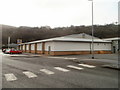
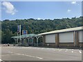
Aldi, Pontymister
Aldi's website gives this store's address as Aldi Risca, Interchange, Risca.
More accurately, it is located opposite the A467/B4591 roundabout in Pontymister, about 200 metres from Commercial Street. The confusion is understandable, since Risca and Pontymister are joined seamlessly, and it is often difficult (certainly for visitors and maybe for many locals) to know exactly where the boundary is.
Image: © Jaggery
Taken: 16 Feb 2011
0.10 miles
5
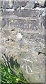
Ordnance Survey Cut Mark
This OS cut mark can be found on the west parapet of Pont y Mister. It marks a point 42.180m above mean sea level.
Image: © Adrian Dust
Taken: 11 May 2019
0.11 miles
6
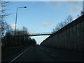
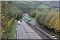
Footbridge across the A467
This footbridge south of Risca has to climb very high above the pictured eastbound lanes of the A467 because the neighbouring westbound lanes are located at a higher level, further up the hill away from the Ebbw River.
Image: © Ruth Riddle
Taken: 28 Dec 2011
0.12 miles
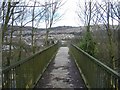
7
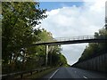
Footbridge over A467 for path from Fields Road
Image: © David Smith
Taken: 27 Sep 2021
0.13 miles
8

Mural, Aldi store
The two men leaning on the gate are looking at a dragon in the field
Image: © David Smith
Taken: 27 Sep 2021
0.13 miles
9
Footbridge across the A467
Looking towards Risca.
Image: © Roger Cornfoot
Taken: 1 Mar 2007
0.15 miles