IMAGES TAKEN NEAR TO
Fields Road, NEWPORT, NP11 6EJ
Introduction
This page details the photographs taken nearby to Fields Road, NP11 6EJ by members of the Geograph project.
The Geograph project started in 2005 with the aim of publishing, organising and preserving representative images for every square kilometre of Great Britain, Ireland and the Isle of Man.

There are currently over 7.5m images from over14,400 individuals and you can help contribute to the project by visiting https://www.geograph.org.uk
Image Map
Images are licensed for reuse under creativecommons.org/licenses/by-sa/2.0
Notes
- Clicking on the map will re-center to the selected point.
- The higher the marker number, the further away the image location is from the centre of the postcode.
Image Listing (85 Images Found)
Images are licensed for reuse under creativecommons.org/licenses/by-sa/2.0
Image
Details
Distance
1
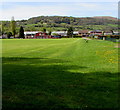
Pontymister Cricket Club cricket field and pavilion
Looking towards the pavilion in Fields Road.
Image: © Jaggery
Taken: 30 Apr 2018
0.03 miles
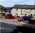
2

Fields Road houses and lockup garages, Pontymister
Looking south from the corner of the B4591.
Image: © Jaggery
Taken: 30 Apr 2018
0.05 miles
3
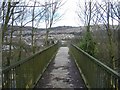
Footbridge across the A467
Looking towards Risca.
Image: © Roger Cornfoot
Taken: 1 Mar 2007
0.07 miles
4
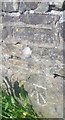
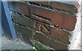
Ordnance Survey Cut Mark
This OS cut mark can be found on the west parapet of Pont y Mister. It marks a point 42.180m above mean sea level.
Image: © Adrian Dust
Taken: 11 May 2019
0.08 miles
5
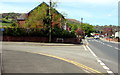
Junction of Fields Road and the B4591, Pontymister
Fields Road from the left joins the B4591.
The sign at the left edge of the photo shows that Fields Road is not a through route.
Image: © Jaggery
Taken: 30 Apr 2018
0.09 miles
6
Ordnance Survey Cut Mark
This OS cut mark can be found on No161 Commercial Street. It marks a point 42.920m above mean sea level.
Image: © Adrian Dust
Taken: 11 May 2019
0.09 miles
7
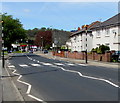
Newport Road bus stop and shelter, Pontymister
This stop alongside the B4591 Newport Road is for buses to Risca, Blackwood, Tredegar etc.
Image: © Jaggery
Taken: 30 Apr 2018
0.09 miles
8
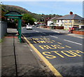
Zebra crossing, Commercial Street, Pontymister
Across the B4591 Commercial Street viewed from the corner of Fields Road.
Although Belisha beacons had marked pedestrian crossings in the UK from 1934, it was not until 1951 that the now familiar black and white stripes stretching across the width of the road were officially introduced. Previously, there were only metal studs across the road surface.
Image: © Jaggery
Taken: 30 Apr 2018
0.09 miles
9
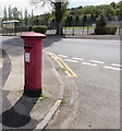
King George V pillarbox on a Pontymister corner
On the right here http://www.geograph.org.uk/photo/5966871 on the corner of Ty Isaf Crescent and the B4591 Newport Road. The GR on the box is short for Georgius Rex, Latin for King George, in this case King George V who reigned from May 1910-January 1936.
Image: © Jaggery
Taken: 30 Apr 2018
0.09 miles
10
Red pillarbox on a Pontymister corner
On the corner of Ty Isaf Crescent and the B4591 Newport Road.
Image: © Jaggery
Taken: 30 Apr 2018
0.09 miles