IMAGES TAKEN NEAR TO
Tir-y-Cwm Lane, NEWPORT, NP11 6DN
Introduction
This page details the photographs taken nearby to Tir-y-Cwm Lane, NP11 6DN by members of the Geograph project.
The Geograph project started in 2005 with the aim of publishing, organising and preserving representative images for every square kilometre of Great Britain, Ireland and the Isle of Man.

There are currently over 7.5m images from over14,400 individuals and you can help contribute to the project by visiting https://www.geograph.org.uk
Image Map
Images are licensed for reuse under creativecommons.org/licenses/by-sa/2.0
Notes
- Clicking on the map will re-center to the selected point.
- The higher the marker number, the further away the image location is from the centre of the postcode.
Image Listing (205 Images Found)
Images are licensed for reuse under creativecommons.org/licenses/by-sa/2.0
Image
Details
Distance
1
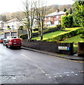
Tir-y-cwm Road, Risca
Tir-y-cwm Road is a 150-metre long cul-de-sac ending at the entrance gates to Danygraig Cemetery. Viewed from underneath the bridge http://www.geograph.org.uk/photo/2715211 carrying the A467 over Danygraig Road.
Image: © Jaggery
Taken: 30 Nov 2011
0.03 miles
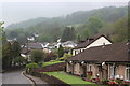
2
Recently-built houses, Tir-y-cwm Road, Risca
Viewed from the cemetery gates http://www.geograph.org.uk/photo/2716349 end of Tir-y-cwm Road.
Image: © Jaggery
Taken: 30 Nov 2011
0.03 miles
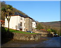
3
Danycraig Bungalows, Tir-Y-Cwm Lane, Risca
Bungalows on the hillside under the clouds during a break in the rain. The terrace in the right foreground, on Dan-y-Craig Road, is housing for the elderly.
Image: © M J Roscoe
Taken: 10 May 2016
0.03 miles
4
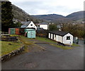
Buildings near Danygraig Cemetery entrance, Risca
The building on the left is similar to some electricity substations such as this one http://www.geograph.org.uk/photo/2232071 but there are no warning notices on it, so it is probably an outhouse. There is a metal container in the middle and a toilet block http://www.geograph.org.uk/photo/3408998 on the right.
Image: © Jaggery
Taken: 11 Apr 2013
0.04 miles
5
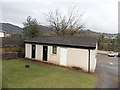
Toilet block, Danygraig Cemetery, Risca
The public toilets are located next to the cemetery entrance from Tir-y-Cwm Road.
Image: © Jaggery
Taken: 11 Apr 2013
0.04 miles
6
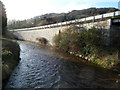
River Ebbw and the A467 embankment, Risca
A view south from the bridge carrying Danygraig Road over the River Ebbw.
http://www.geograph.org.uk/photo/2715219 to a view from the opposite side.
Image: © Jaggery
Taken: 30 Nov 2011
0.04 miles
7
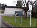
Notices at the entrance to Danygraig Cemetery, Risca
Viewed from the southern end of Tir-y-Cwm Road.
One notice shows a layout of the cemetery and gives the cemetery's opening hours.
The other one shows Please leave cars in car park.
Image: © Jaggery
Taken: 11 Apr 2013
0.04 miles
8
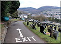
Approaching the exit from Danygraig Cemetery, Risca
A one-way clockwise traffic system operates in the cemetery.
In the distance is Twmbarlwm. Image Its summit is 419 metres (1,375 ft) above mean sea level.
Image: © Jaggery
Taken: 11 Apr 2013
0.05 miles
9
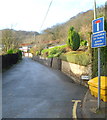
Tir-y-cwm Lane unsuitable for HGVs
Viewed from Danygraig Road.
Image: © Jaggery
Taken: 30 Nov 2011
0.05 miles
10
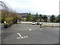
Northern car park, Danygraig Cemetery, Risca
This small car park is near the entrance to the cemetery from Tir-y-Cwm Road.
There is another car park http://www.geograph.org.uk/photo/3408986 at the far end of the cemetery.
Image: © Jaggery
Taken: 11 Apr 2013
0.05 miles