IMAGES TAKEN NEAR TO
Wesley Place, NEWPORT, NP11 6BZ
Introduction
This page details the photographs taken nearby to Wesley Place, NP11 6BZ by members of the Geograph project.
The Geograph project started in 2005 with the aim of publishing, organising and preserving representative images for every square kilometre of Great Britain, Ireland and the Isle of Man.

There are currently over 7.5m images from over14,400 individuals and you can help contribute to the project by visiting https://www.geograph.org.uk
Image Map
Images are licensed for reuse under creativecommons.org/licenses/by-sa/2.0
Notes
- Clicking on the map will re-center to the selected point.
- The higher the marker number, the further away the image location is from the centre of the postcode.
Image Listing (265 Images Found)
Images are licensed for reuse under creativecommons.org/licenses/by-sa/2.0
Image
Details
Distance
1
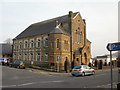
Moriah Baptist Church, Risca
Located on Tredegar Street, at the corner of Park Road opposite the former bank premises. http://www.geograph.org.uk/photo/1748755
Moriah Baptist Church was formed on Christmas Day 1835. Two preaching services were held that day and were conducted in Welsh, the language spoken by most of the residents in the area at the time.
There were great changes locally during the last quarter of the 19th century, with the opening of coal mines, steel making and tinplate production. The area became anglicised with the influx of people from the English border counties, and beyond, seeking employment.
In the last decade of the 19th century, the church members decided to build a new church, seen here, to accommodate the increase in population. The church opened in 1894, with a seating capacity of 1,100. Services were now conducted in English.
The building was Grade II listed in 1999.
Image: © Jaggery
Taken: 11 Mar 2010
0.01 miles
2
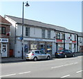
Barclays Bank, Risca
Bank branch at 52 Tredegar Street. Next door is Motaquote, insurance brokers.
Image: © Jaggery
Taken: 10 Apr 2011
0.01 miles
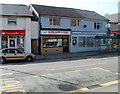
3
HSBC, Risca
Bank branch at 57 Tredegar Street, on the corner of Tredegar Terrace.
Next door is The Co-operative Pharmacy.
Image: © Jaggery
Taken: 10 Apr 2011
0.01 miles
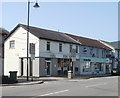
4
Williams butchers, Risca
Premises of M Williams & Sons, butchers, 47 Tredegar Street.
On the left is a Santander agency. On the right is Phillips Opticians.
Image: © Jaggery
Taken: 10 Apr 2011
0.01 miles
5
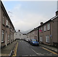
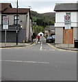
Wesley Place, Risca
North along Wesley Place from Tredegar Terrace towards Graig View.
Image: © Jaggery
Taken: 20 Dec 2016
0.01 miles
6
No parking in Tredegar Terrace, Risca
Double yellow lines on both sides indicate no parking at any time.
Image: © Jaggery
Taken: 20 Dec 2016
0.02 miles
7
East side of the St John Ambulance hall, Risca
The Tredegar Terrace side of this http://www.geograph.org.uk/photo/5232533 building.
Image: © Jaggery
Taken: 20 Dec 2016
0.03 miles
8
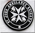
St John Ambulance Brigade logo, Risca
Located here. http://www.geograph.org.uk/photo/5232547. The central feature of the logo is an eight-pointed Maltese Cross. The St John Ambulance Brigade was formed in June 1887 as a uniformed organisation to provide first aid and ambulance services at public events.
Image: © Jaggery
Taken: 20 Dec 2016
0.03 miles
9
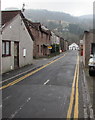
West along Tredegar Terrace, Risca
The 30mph speed limit on the B4591 Tredegar Street drops to 20mph along Tredegar Terrace.
Image: © Jaggery
Taken: 28 Apr 2018
0.03 miles
10
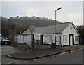
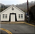
St John Ambulance hall, Risca
Located at the rugby ground end of Tredegar Terrace, on a bank of the Ebbw River. In December 2016, a notice on the fence states that a children's self defence class is held here every Tuesday from 5pm-6pm.
Image: © Jaggery
Taken: 20 Dec 2016
0.03 miles