IMAGES TAKEN NEAR TO
Brookland Road, NEWPORT, NP11 6BH
Introduction
This page details the photographs taken nearby to Brookland Road, NP11 6BH by members of the Geograph project.
The Geograph project started in 2005 with the aim of publishing, organising and preserving representative images for every square kilometre of Great Britain, Ireland and the Isle of Man.

There are currently over 7.5m images from over14,400 individuals and you can help contribute to the project by visiting https://www.geograph.org.uk
Image Map
Images are licensed for reuse under creativecommons.org/licenses/by-sa/2.0
Notes
- Clicking on the map will re-center to the selected point.
- The higher the marker number, the further away the image location is from the centre of the postcode.
Image Listing (200 Images Found)
Images are licensed for reuse under creativecommons.org/licenses/by-sa/2.0
Image
Details
Distance
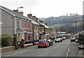
1
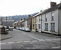
Brookland Road, Risca
Houses on the west side of Brookland Road, viewed from the corner of Park Road.
Image: © Jaggery
Taken: 11 Mar 2010
0.03 miles
2
Clyde Street, Pontymister
From the corner of Commercial Street, north along Clyde Street towards Wellspring Terrace.
Image: © Jaggery
Taken: 22 Jun 2018
0.05 miles
3
Risca Citizens Advice Bureau
Located on Park Road. The Citizens Advice service helps people resolve their legal, money and other problems by providing free information and advice, and by influencing policy makers.
Image: © Jaggery
Taken: 11 Mar 2010
0.06 miles
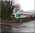
4
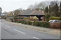
Wellspring Medical Centre, Risca
Located on Park Road. The medical centre opened in December 1991 in these purpose-built premises.
Image: © Jaggery
Taken: 11 Mar 2010
0.06 miles
5
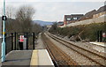
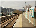
The view from the northern edge of platform 1, Risca and Pontymister railway station
The next station in this direction is Crosskeys, on the route to Ebbw Vale Parkway.
Risca and Pontymister station was built in 2007 and opened in February 2008 when services between Cardiff Central and Ebbw Vale Parkway began. An hourly service to Newport is planned.
Image: © Jaggery
Taken: 11 Mar 2010
0.06 miles
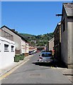
6
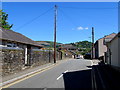
Wires over Brookland Road, Pontymister
Telephone wires radiate from a pole near the southern end of Brookland Road.
Image: © Jaggery
Taken: 22 Jun 2018
0.09 miles
7
Lyne Road, Risca
Houses on the east side of Lyne Road, viewed from near the corner of Park Road.
Image: © Jaggery
Taken: 11 Mar 2010
0.09 miles
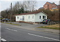
8
Twyncarn Day Centre, Pontymister
Located in Brooklands Road, viewed from Commercial Street, Pontymister.
Twyncarn Day Centre is a specially adapted building within Brooklands Day Centre.
Image: © Jaggery
Taken: 11 Apr 2013
0.09 miles
9
Platform 2, Risca and Pontymister railway station
Looking west along platform 2. The next station in this direction is Crosskeys ; in the opposite direction, Rogerstone.
The site was originally railway sidings. The station has two platforms and a park and ride car park. The main access to the station is from Maryland Road, with pedestrian access also from Mill Street.
The station opened in February 2008 when services between Cardiff Central and Ebbw Vale Parkway began. An hourly service to Newport is planned.
Image: © Jaggery
Taken: 11 Mar 2010
0.10 miles
10
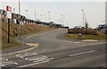
Main entrance to Risca and Pontymister railway station
Viewed from Maryland Road. There is also a pedestrian entrance http://www.geograph.org.uk/photo/1750531 at the other end of the station.
Image: © Jaggery
Taken: 11 Mar 2010
0.10 miles