IMAGES TAKEN NEAR TO
Malvern Terrace, NEWPORT, NP11 6AU
Introduction
This page details the photographs taken nearby to Malvern Terrace, NP11 6AU by members of the Geograph project.
The Geograph project started in 2005 with the aim of publishing, organising and preserving representative images for every square kilometre of Great Britain, Ireland and the Isle of Man.

There are currently over 7.5m images from over14,400 individuals and you can help contribute to the project by visiting https://www.geograph.org.uk
Image Map
Images are licensed for reuse under creativecommons.org/licenses/by-sa/2.0
Notes
- Clicking on the map will re-center to the selected point.
- The higher the marker number, the further away the image location is from the centre of the postcode.
Image Listing (227 Images Found)
Images are licensed for reuse under creativecommons.org/licenses/by-sa/2.0
Image
Details
Distance
1
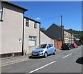
Malvern Terrace, Pontymister
The southern end of a cul-de-sac viewed from the corner of the B4591 Commercial Street.
Image: © Jaggery
Taken: 22 Jun 2018
0.04 miles
2
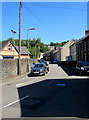
Sunshine and shadows, Station Road, Risca
Viewed on June 22nd 2018. Station Road leads to the site of the old Risca station, which closed in 1962 on the cessation of passenger services. The present-day Risca & Pontymister station https://www.geograph.org.uk/photo/1749458 opened in 2008 about 500 metres east of the former station.
Image: © Jaggery
Taken: 22 Jun 2018
0.04 miles
3
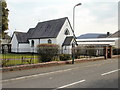
The Catholic Church, Risca
On the corner of Park Road and Lyne Road.
On its notice board, the church calls itself The Catholic Church Risca. On the next line it lists St Anthony of Padua and St Clare of Assisi (though the board shows Assissi).
The church is in the archdiocese of Cardiff.
Image: © Jaggery
Taken: 11 Mar 2010
0.04 miles
4
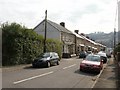
Park Place, Risca
Houses on the east side of Park Place, viewed from the corner of Park Road.
Image: © Jaggery
Taken: 11 Mar 2010
0.04 miles
5
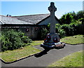
Pontymister War Memorial
Located in a small garden on the corner of Station Road and Commercial Street, on the Pontymister side of the boundary with Risca. Originally in the grounds of Pontywaun Grammar School, the Memorial was moved here in 2011. A small plaque https://www.geograph.org.uk/photo/5825994 on the wall behind the Memorial Cross records that this site was created in 1951 to mark the Festival of Britain held in that year.
Image: © Jaggery
Taken: 22 Jun 2018
0.04 miles
6
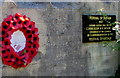
Festival of Britain 1951 plaque, Pontymister
On the wall in the background here. https://www.geograph.org.uk/photo/5825991
Image: © Jaggery
Taken: 22 Jun 2018
0.05 miles
7
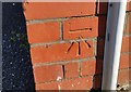
Ordnance Survey Cut Mark
This OS cut mark can be found on the south angle of the Police Station. It marks a point 45.479m above mean sea level.
Image: © Adrian Dust
Taken: 11 May 2019
0.05 miles
8
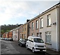
Malvern Terrace, Pontymister
A view south, looking towards Commercial Street (B4591) from the edge of allotments.
The houses are all on the west side of the street. Lock-up garages are on the east side.
Image: © Jaggery
Taken: 30 Nov 2011
0.06 miles
9
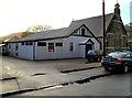
St Margaret's church hall, Pontymister
Viewed across Malvern Terrace. The church hall is alongside the Church in Wales church. http://www.geograph.org.uk/photo/2704941
Image: © Jaggery
Taken: 30 Nov 2011
0.06 miles
10

Southeast side of St Margaret's Church, Risca
Viewed across Park Place from the corner of Commercial Street. The building was erected in 1910-1911.
The church is part of the Church in Wales Benefice of Lower Islwyn in the Diocese of Monmouth.
Image: © Jaggery
Taken: 22 Jun 2018
0.06 miles