IMAGES TAKEN NEAR TO
Lyne Road, NEWPORT, NP11 6AT
Introduction
This page details the photographs taken nearby to Lyne Road, NP11 6AT by members of the Geograph project.
The Geograph project started in 2005 with the aim of publishing, organising and preserving representative images for every square kilometre of Great Britain, Ireland and the Isle of Man.

There are currently over 7.5m images from over14,400 individuals and you can help contribute to the project by visiting https://www.geograph.org.uk
Image Map
Images are licensed for reuse under creativecommons.org/licenses/by-sa/2.0
Notes
- Clicking on the map will re-center to the selected point.
- The higher the marker number, the further away the image location is from the centre of the postcode.
Image Listing (207 Images Found)
Images are licensed for reuse under creativecommons.org/licenses/by-sa/2.0
Image
Details
Distance
1
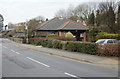
Risca Citizens Advice Bureau
Located on Park Road. The Citizens Advice service helps people resolve their legal, money and other problems by providing free information and advice, and by influencing policy makers.
Image: © Jaggery
Taken: 11 Mar 2010
0.02 miles
2
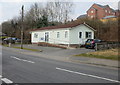
Wellspring Medical Centre, Risca
Located on Park Road. The medical centre opened in December 1991 in these purpose-built premises.
Image: © Jaggery
Taken: 11 Mar 2010
0.02 miles
3
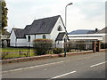
The Catholic Church, Risca
On the corner of Park Road and Lyne Road.
On its notice board, the church calls itself The Catholic Church Risca. On the next line it lists St Anthony of Padua and St Clare of Assisi (though the board shows Assissi).
The church is in the archdiocese of Cardiff.
Image: © Jaggery
Taken: 11 Mar 2010
0.05 miles
4
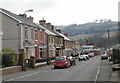
Park Place, Risca
Houses on the east side of Park Place, viewed from the corner of Park Road.
Image: © Jaggery
Taken: 11 Mar 2010
0.05 miles
5
Brookland Road, Risca
Houses on the west side of Brookland Road, viewed from the corner of Park Road.
Image: © Jaggery
Taken: 11 Mar 2010
0.05 miles
6
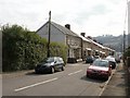
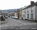
Lyne Road, Risca
Houses on the east side of Lyne Road, viewed from near the corner of Park Road.
Image: © Jaggery
Taken: 11 Mar 2010
0.07 miles
7
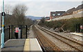
The view from the northern edge of platform 1, Risca and Pontymister railway station
The next station in this direction is Crosskeys, on the route to Ebbw Vale Parkway.
Risca and Pontymister station was built in 2007 and opened in February 2008 when services between Cardiff Central and Ebbw Vale Parkway began. An hourly service to Newport is planned.
Image: © Jaggery
Taken: 11 Mar 2010
0.08 miles
8
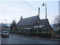
St Margaret's Church after the Snow
St Margaret's church with the previous night's snow still on walls and pavement.
Image: © David Roberts
Taken: 21 Dec 2009
0.09 miles
9
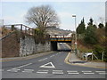
Gelli Avenue railway bridge, Risca
Gelli Avenue heads away from Park Road under an 11 foot 3 inch headroom railway bridge. The bridge carries the Cardiff Central to Ebbw Vale Parkway route, a little northwest of Risca and Pontymister railway station.
Image: © Jaggery
Taken: 11 Mar 2010
0.09 miles
10
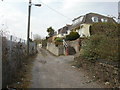
Hillside, Risca
The side street Hillside runs parallel with the railway line. It connects with Gelli Avenue.
Image: © Jaggery
Taken: 11 Mar 2010
0.09 miles