IMAGES TAKEN NEAR TO
Maple Gardens, NEWPORT, NP11 6AR
Introduction
This page details the photographs taken nearby to Maple Gardens, NP11 6AR by members of the Geograph project.
The Geograph project started in 2005 with the aim of publishing, organising and preserving representative images for every square kilometre of Great Britain, Ireland and the Isle of Man.

There are currently over 7.5m images from over14,400 individuals and you can help contribute to the project by visiting https://www.geograph.org.uk
Image Map
Images are licensed for reuse under creativecommons.org/licenses/by-sa/2.0
Notes
- Clicking on the map will re-center to the selected point.
- The higher the marker number, the further away the image location is from the centre of the postcode.
Image Listing (45 Images Found)
Images are licensed for reuse under creativecommons.org/licenses/by-sa/2.0
Image
Details
Distance
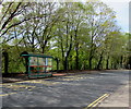
1
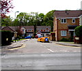
Maple Gardens, Pontymister
Cul-de-sac on the south side of the B4591 Newport Road.
The houses in the background are on the north bank of the Ebbw River.
Image: © Jaggery
Taken: 30 Apr 2018
0.01 miles
2
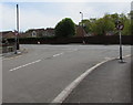
Mandatory left turn at the SE end of Meadow Crescent, Pontymister
No Right Turn signs are on the approach to the B4591 Newport Road.
A few seconds after I'd taken this photo, a van turned right into Newport Road...
Image: © Jaggery
Taken: 30 Apr 2018
0.04 miles
3
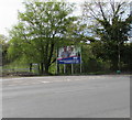
Suflex board, Pontymister
The board on the south side of the B4591 shows
"Suflex enabling works for construction of show house and development of 87 new homes".
Viewed in April 2018. The same text is on the board in an October 2015 Google Earth Street View.
Image: © Jaggery
Taken: 30 Apr 2018
0.04 miles
4
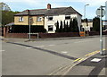
Semis on a Pontymister corner
Semi-detached houses on the corner of Meadow Crescent and the B4591 Newport Road in Pontymister.
Image: © Jaggery
Taken: 30 Apr 2018
0.05 miles
5
Newport Road bus stop and shelter, Pontymister
This stop on the south side of the B4591 Newport Road is for buses to Risca, Cross Keys, Blackwood etc.
Image: © Jaggery
Taken: 30 Apr 2018
0.06 miles
6
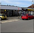
Pricedown Stores, Meadow Crescent, Pontymister
A Premier convenience store viewed in April 2018.
A July 2012 Google Earth Street View shows a Londis convenience store here.
Image: © Jaggery
Taken: 30 Apr 2018
0.08 miles
7
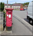
King George VI pillarbox, Meadow Crescent, Pontymister
In need of a repaint in April 2018, the pillarbox is located near Pricedown Stores.
The top of the pillarbox is in the background here https://www.geograph.org.uk/photo/5757321 behind the red phonebox.
King George VI reigned from December 11th 1936 to February 6th 1952.
Image: © Jaggery
Taken: 30 Apr 2018
0.08 miles
8
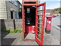
Former red phonebox, Meadow Crescent, Pontymister
The telephone formerly in the box has been removed by BT.
A Payphone Kiosk Removal notice remains in the box on April 30th 2018.
Image: © Jaggery
Taken: 30 Apr 2018
0.08 miles
9
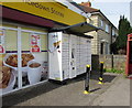
InPost terminal outside Pricedown Stores, Meadow Crescent, Pontymister
Shop online, receive a text with a unique code which you use to open the locker into which your parcel has been placed. The lockers, which are available all day every day, can also be used to send parcels.
Image: © Jaggery
Taken: 30 Apr 2018
0.08 miles
10

Meadow Crescent, Pontymister
From the corner of Newport Road along Meadow Crescent towards Ty-Isaf Park Avenue.
Pricedown Stores, https://www.geograph.org.uk/photo/5757305 a Premier convenience store, is on the left.
Image: © Jaggery
Taken: 30 Apr 2018
0.08 miles