IMAGES TAKEN NEAR TO
Twyn Road, NEWPORT, NP11 5JY
Introduction
This page details the photographs taken nearby to Twyn Road, NP11 5JY by members of the Geograph project.
The Geograph project started in 2005 with the aim of publishing, organising and preserving representative images for every square kilometre of Great Britain, Ireland and the Isle of Man.

There are currently over 7.5m images from over14,400 individuals and you can help contribute to the project by visiting https://www.geograph.org.uk
Image Map
Images are licensed for reuse under creativecommons.org/licenses/by-sa/2.0
Notes
- Clicking on the map will re-center to the selected point.
- The higher the marker number, the further away the image location is from the centre of the postcode.
Image Listing (69 Images Found)
Images are licensed for reuse under creativecommons.org/licenses/by-sa/2.0
Image
Details
Distance
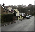
1
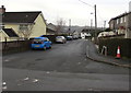
Clytha Square, Llanfach, Abercarn
From Llanfach Road along Clytha Square towards Twyn Road.
Image: © Jaggery
Taken: 7 Jan 2017
0.03 miles
2

Clytha Square bus stop and shelter, Llanfach, Abercarn
In January 2017, the timetable in the shelter shows that this stop is for buses on route N2 to Crumlin via Newbridge and Treowen. Provided by Harris Coaches, a bus is scheduled to leave here hourly at 32 minutes past, from 7:32am until 6:32pm Mondays - Saturdays. No buses on Sundays or Bank Holiday Mondays.
Newbridge railway station is near the Newbridge bus stop on this route.
Image: © Jaggery
Taken: 7 Jan 2017
0.03 miles
4
Rooftop solar panels, Twyn Road, Llanfach, Abercarn
Viewed from the corner of Clytha Square.
Image: © Jaggery
Taken: 7 Jan 2017
0.05 miles
5
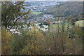
Llanfach, Abercarn
Viewed above Cwm Gwyddon from Rhyswg Fawr. The southern part of Newbridge is top left.
Image: © M J Roscoe
Taken: 14 Oct 2020
0.06 miles
6
Twyn Road towards a children's playground, Llanfach, Abercarn
The road ascends past a playground warning sign.
Image: © Jaggery
Taken: 7 Jan 2017
0.06 miles
7

Openreach van, Llanfach Road, Llanfach, Abercarn
Openreach is the infrastructure division of the telecommunications company BT Group.
Image: © Jaggery
Taken: 7 Jan 2017
0.06 miles
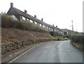
8

Down Llanfach Road, Llanfach, Abercarn
From the edge of this fence and field, http://www.geograph.org.uk/photo/5252461 Llanfach Road descends into the Llanfach area of Abercarn.
Image: © Jaggery
Taken: 7 Jan 2017
0.06 miles
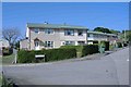
9
Penrhiw Terrace, Abercarn
Viewed from the Cemetery Road end. This section of Penrhiw Terrace runs parallel with Persondy Terrace, http://www.geograph.org.uk/photo/2286422 a few metres beyond the right edge of the view.
Image: © Jaggery
Taken: 24 Jan 2011
0.06 miles
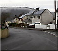
10
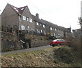
Persondy Terrace, Abercarn
Semi-detached houses viewed from the north end of Cemetery Road.
Image: © Jaggery
Taken: 24 Jan 2011
0.06 miles