IMAGES TAKEN NEAR TO
Upper Brook Street, NEWPORT, NP11 5JJ
Introduction
This page details the photographs taken nearby to Upper Brook Street, NP11 5JJ by members of the Geograph project.
The Geograph project started in 2005 with the aim of publishing, organising and preserving representative images for every square kilometre of Great Britain, Ireland and the Isle of Man.

There are currently over 7.5m images from over14,400 individuals and you can help contribute to the project by visiting https://www.geograph.org.uk
Image Map
Images are licensed for reuse under creativecommons.org/licenses/by-sa/2.0
Notes
- Clicking on the map will re-center to the selected point.
- The higher the marker number, the further away the image location is from the centre of the postcode.
Image Listing (27 Images Found)
Images are licensed for reuse under creativecommons.org/licenses/by-sa/2.0
Image
Details
Distance
1
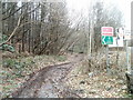
Public footpath near Hafod Quarry, Abercarn
A footpath branches away from the road to the quarry entrance. http://www.geograph.org.uk/photo/2295887
Image: © Jaggery
Taken: 23 Jan 2011
0.04 miles
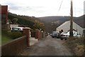
2
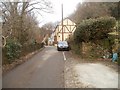
Oak Street, Abercarn
The view along semi-rural Oak Street towards a row of four houses on the east side of the street.
Image: © Jaggery
Taken: 24 Jan 2011
0.07 miles
3
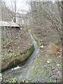
Channelled brook, Brook Street, Abercarn
A brook flows down a channel on the east side of Brook Street.
Image: © Jaggery
Taken: 23 Jan 2011
0.10 miles
4
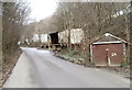
Storage facilities, Brook Street, Abercarn
Behind a lock-up shed is a long-abandoned road trailer, with half of its side missing.
Image: © Jaggery
Taken: 23 Jan 2011
0.10 miles
5
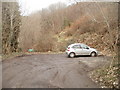
Turning area at the far end of Chapel Street, Abercarn
The turning area is at the edge of woods named Craig Glan-sion.
Image: © Jaggery
Taken: 24 Jan 2011
0.10 miles
6
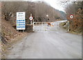
Entrance to Hafod Quarry, Abercarn
The entrance to the sandstone quarry http://www.geograph.org.uk/photo/423389 is at the far (NE) end of Brook Street.
Image: © Jaggery
Taken: 23 Jan 2011
0.11 miles
7
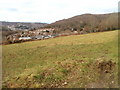
Field bordering Chapel Street, Abercarn
Viewed from a path http://www.geograph.org.uk/photo/2286549
The field is between Abercarn cemetery http://www.geograph.org.uk/photo/2286446 and Chapel Street.
Image: © Jaggery
Taken: 24 Jan 2011
0.16 miles
8
Chapel Street, Abercarn
The view to the south along Chapel Street, a cul-de-sac connecting with Hill Street (ahead).
Image: © Jaggery
Taken: 24 Jan 2011
0.16 miles
9
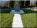
Mining disaster memorial at Abercarn
In September 1878 an underground explosion at the Prince of Wales Colliery, Abercarn killed some 272 men and boys. It is the third biggest loss of life in mining accidents in Wales. So large that both faces of this memorial stone are covered with the names of those lost. Every household locally would have been affected, some with two or even three generations of men wiped out.
Image: © Jeremy Bolwell
Taken: 11 Feb 2012
0.17 miles
10
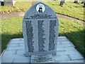
Abercarn mining disaster memorial
The names of men who were lost underground in 1878 in an explosion. Rest in Peace.
Image: © Jeremy Bolwell
Taken: 11 Feb 2012
0.17 miles