IMAGES TAKEN NEAR TO
Cemetery Road, NEWPORT, NP11 5JB
Introduction
This page details the photographs taken nearby to Cemetery Road, NP11 5JB by members of the Geograph project.
The Geograph project started in 2005 with the aim of publishing, organising and preserving representative images for every square kilometre of Great Britain, Ireland and the Isle of Man.

There are currently over 7.5m images from over14,400 individuals and you can help contribute to the project by visiting https://www.geograph.org.uk
Image Map
Images are licensed for reuse under creativecommons.org/licenses/by-sa/2.0
Notes
- Clicking on the map will re-center to the selected point.
- The higher the marker number, the further away the image location is from the centre of the postcode.
Image Listing (40 Images Found)
Images are licensed for reuse under creativecommons.org/licenses/by-sa/2.0
Image
Details
Distance
1

Ordnance Survey Cut Mark
This OS cut mark can be found on the mortuary at Abercarn Cemetery. It marks a point 171.724m above mean sea level.
Image: © Adrian Dust
Taken: 16 Aug 2021
0.02 miles
2
Former chapel, Abercarn cemetery
The disused chapel in Abercarn cemetery was formerly used for funeral services.
Image: © Jaggery
Taken: 24 Jan 2011
0.03 miles
3
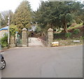
Former mortuary, Abercarn cemetery
The building, recently renovated, is adjacent to the cemetery entrance. It was formerly the mortuary, where a coffin was received before a funeral service in the cemetery chapel. http://www.geograph.org.uk/photo/2286532 This practice ceased when the chapel closed down.
Image: © Jaggery
Taken: 24 Jan 2011
0.03 miles
4
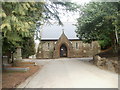
Entrance to Abercarn Cemetery
The cemetery is located on high ground on the NE side of Abercarn. The cemetery, occupying a site of 5 hectares (about 12 acres), opened in 1901.
Image: © Jaggery
Taken: 24 Jan 2011
0.03 miles
5
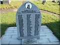
Abercarn mining disaster memorial
The names of men who were lost underground in 1878 in an explosion. Rest in Peace.
Image: © Jeremy Bolwell
Taken: 11 Feb 2012
0.06 miles
6
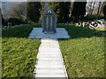
Mining disaster memorial at Abercarn
In September 1878 an underground explosion at the Prince of Wales Colliery, Abercarn killed some 272 men and boys. It is the third biggest loss of life in mining accidents in Wales. So large that both faces of this memorial stone are covered with the names of those lost. Every household locally would have been affected, some with two or even three generations of men wiped out.
Image: © Jeremy Bolwell
Taken: 11 Feb 2012
0.06 miles
7

Ordnance Survey Cut Mark
This OS cut mark can be found on the gatepost of Abercarn Cemetery on Cemetery Road. It marks a point 195.499m above mean sea level.
Image: © Adrian Dust
Taken: 16 Aug 2021
0.07 miles
8
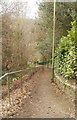
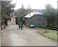
Path from Abercarn cemetery to Hill Street
A path descends from Cemetery Road towards Hill Street, past the southern edge of Abercarn cemetery.
Image: © Jaggery
Taken: 24 Jan 2011
0.10 miles
9
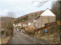
Laburnum Terrace, Abercarn
Viewed from the Cemetery Road end.
Image: © Jaggery
Taken: 24 Jan 2011
0.12 miles
10
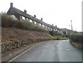
Penrhiw Terrace, Abercarn
Viewed from the Cemetery Road end. This section of Penrhiw Terrace runs parallel with Persondy Terrace, http://www.geograph.org.uk/photo/2286422 a few metres beyond the right edge of the view.
Image: © Jaggery
Taken: 24 Jan 2011
0.13 miles