IMAGES TAKEN NEAR TO
Gwyddon Road, NEWPORT, NP11 5GY
Introduction
This page details the photographs taken nearby to Gwyddon Road, NP11 5GY by members of the Geograph project.
The Geograph project started in 2005 with the aim of publishing, organising and preserving representative images for every square kilometre of Great Britain, Ireland and the Isle of Man.

There are currently over 7.5m images from over14,400 individuals and you can help contribute to the project by visiting https://www.geograph.org.uk
Image Map
Images are licensed for reuse under creativecommons.org/licenses/by-sa/2.0
Notes
- Clicking on the map will re-center to the selected point.
- The higher the marker number, the further away the image location is from the centre of the postcode.
Image Listing (136 Images Found)
Images are licensed for reuse under creativecommons.org/licenses/by-sa/2.0
Image
Details
Distance
1
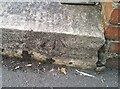
Ordnance Survey Rivet
This OS rivet can be found on the step of the Sub-Station on Gwyddon Road. It marks a point 126.169m above mean sea level.
Image: © Adrian Dust
Taken: 16 Aug 2021
0.02 miles
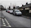
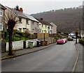
3
Gwyddon Road and Upper Gwyddon Road, Abercarn
Upper Gwyddon Road on the left merges with Gwyddon Road on the far side of the red stand-mounted postbox. The houses in the two roads are numbered in the same sequence - the lowest numbers are allocated to Gwyddon Road houses out of shot to the west http://www.geograph.org.uk/photo/2243401 and the sequence is continued with the westernmost house on Upper Gwyddon Road.
Image: © Jaggery
Taken: 23 Jan 2011
0.05 miles
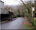
4
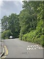
Down Coed Moelfa Road, Llanfach, Abercarn
Coed Moelfa Road descends from Llanfach Road towards Gwyddon Road.
Image: © Jaggery
Taken: 7 Jan 2017
0.07 miles
5
East along Llanfach Road, Llanfach, Abercarn
Llanfach Road ascends from the Coed Moelfa Road junction.
Image: © Jaggery
Taken: 7 Jan 2017
0.08 miles
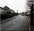
6
N2 bus stop, Coed Moelfa Road, Llanfach, Abercarn
The stop is below the Llanfach Road junction on bus route N2 to Crumlin via Newbridge.
Image: © Jaggery
Taken: 7 Jan 2017
0.08 miles
7
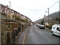
Llanfach Road approaches the Bryn Road junction, Llanfach, Abercarn
Part of the long steep ascent through the Llanfach area of Abercarn.
Image: © Jaggery
Taken: 7 Jan 2017
0.09 miles
8
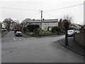
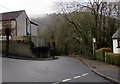
Corner of Coed Moelfa Road and Llanfach Road, Llanfach, Abercarn
Wires radiate from a pole on the corner.
Image: © Jaggery
Taken: 7 Jan 2017
0.09 miles
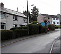
9
Winter view of two pollarded trees, Bryn Road, Llanfach, Abercarn
Viewed in early January 2017.
Image: © Jaggery
Taken: 7 Jan 2017
0.10 miles
10
Up Llanfach Road, Llanfach, Abercarn
Part of a long steep ascent through the Llanfach area of Abercarn.
Image: © Jaggery
Taken: 7 Jan 2017
0.10 miles