IMAGES TAKEN NEAR TO
Gwyddon Road, NEWPORT, NP11 5GX
Introduction
This page details the photographs taken nearby to Gwyddon Road, NP11 5GX by members of the Geograph project.
The Geograph project started in 2005 with the aim of publishing, organising and preserving representative images for every square kilometre of Great Britain, Ireland and the Isle of Man.

There are currently over 7.5m images from over14,400 individuals and you can help contribute to the project by visiting https://www.geograph.org.uk
Image Map
Images are licensed for reuse under creativecommons.org/licenses/by-sa/2.0
Notes
- Clicking on the map will re-center to the selected point.
- The higher the marker number, the further away the image location is from the centre of the postcode.
Image Listing (162 Images Found)
Images are licensed for reuse under creativecommons.org/licenses/by-sa/2.0
Image
Details
Distance
1
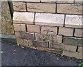
Ordnance Survey Cut Mark
This OS cut mark can be found on the Old School building on Gwyddon Road. It marks a point 112.191m above mean sea level.
Image: © Adrian Dust
Taken: 16 Aug 2021
0.03 miles
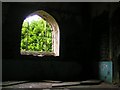
2
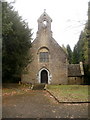
The Welsh Church, Abercarn
This appeared to be a derelict church, but a local assured me it is still in use.
I entered the churchyard by walking north up a long path from Gwyddon Road.
There is a vehicular entrance from the west.
Image: © Jaggery
Taken: 23 Jan 2011
0.04 miles
3

Disused police station in Abercarn
Now for sale but a sad sight. Good to imagine it being put to good use again though.
Image: © Jeremy Bolwell
Taken: 7 Apr 2013
0.04 miles
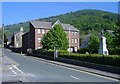
4
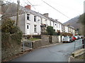
Row of nine houses, Gwyddon Road, Abercarn
Numbered consecutively (3 to 11), these nine houses are on the north side of Gwyddon Road.
Image: © Jaggery
Taken: 23 Jan 2011
0.05 miles
6
Ysgol Gymraeg Cwm Gwyddon, Abercarn
Welsh medium primary school viewed from the Market Place entrance gates. http://www.geograph.org.uk/photo/5256775
The School Guide website states that this school serves a large area including Newbridge, Abercarn, Cwmcarn, Risca and Hafodyrynys. The school has 242 pupils between the ages of 3 and 11, including 26 nursery age children and 15 pre-nursery age children. Pupils start here at the beginning of the term after their third birthday. 98% per cent of the pupils are from white ethnic backgrounds. About 6% come from Welsh-speaking homes.
Image: © Jaggery
Taken: 14 Jan 2017
0.06 miles
7
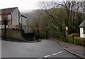
Down Coed Moelfa Road, Llanfach, Abercarn
Coed Moelfa Road descends from Llanfach Road towards Gwyddon Road.
Image: © Jaggery
Taken: 7 Jan 2017
0.06 miles