IMAGES TAKEN NEAR TO
High Street, NEWPORT, NP11 5GQ
Introduction
This page details the photographs taken nearby to High Street, NP11 5GQ by members of the Geograph project.
The Geograph project started in 2005 with the aim of publishing, organising and preserving representative images for every square kilometre of Great Britain, Ireland and the Isle of Man.

There are currently over 7.5m images from over14,400 individuals and you can help contribute to the project by visiting https://www.geograph.org.uk
Image Map
Images are licensed for reuse under creativecommons.org/licenses/by-sa/2.0
Notes
- Clicking on the map will re-center to the selected point.
- The higher the marker number, the further away the image location is from the centre of the postcode.
Image Listing (172 Images Found)
Images are licensed for reuse under creativecommons.org/licenses/by-sa/2.0
Image
Details
Distance
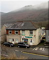
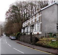
1
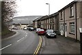
High Street houses alongside a bend, Abercarn
The houses are on the west side of the B4591 High Street.
Image: © Jaggery
Taken: 7 Jan 2017
0.00 miles
2
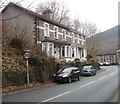
Rock Villas, Abercarn
Two semi-detached houses located at the NE edge of High Street. A stone inscription between the third and fourth upstairs windows shows
ROCK
1894
VILLAS.
Image: © Jaggery
Taken: 23 Jan 2011
0.02 miles
4
Garn Street, Abercarn
Dead-end street descending from the west side of the B4591 High Street to railings above the A467.
Image: © Jaggery
Taken: 7 Jan 2017
0.04 miles
5
Abercarn Post Office
Post office at 21 High Street, viewed from Twyn Road.
Image: © Jaggery
Taken: 7 Jan 2017
0.05 miles
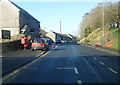
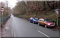
6

Start of the 30 zone, High Street, Abercarn
The 40mph speed limit on the B4591 drops to 30mph at the northern edge of High Street.
Image: © Jaggery
Taken: 7 Jan 2017
0.05 miles
7
End of the 30 zone on High Street, Abercarn
The 30mph speed limit on the B4591 increases to 40mph.
The Cemetery Road junction http://www.geograph.org.uk/photo/5247696 is in the background.
Image: © Jaggery
Taken: 7 Jan 2017
0.05 miles
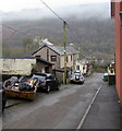
8
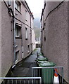
Vine Street, Abercarn
Narrow street on the west side of High Street.
Image: © Jaggery
Taken: 7 Jan 2017
0.05 miles
9
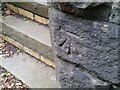
Ordnance Survey Cut Mark
This OS cut mark can be found on the wall of No36 High Street. It marks a point 113.300m above mean sea level.
Image: © Adrian Dust
Taken: 16 Aug 2021
0.05 miles
10
Late Victorian Rock Villas, High Street, Abercarn
The inscription on the wall of the semi-detached houses shows ROCK VILLAS 1894.
Image: © Jaggery
Taken: 7 Jan 2017
0.06 miles