IMAGES TAKEN NEAR TO
Price's Row, High Street, NEWPORT, NP11 5GJ
Introduction
This page details the photographs taken nearby to Price's Row, High Street, NP11 5GJ by members of the Geograph project.
The Geograph project started in 2005 with the aim of publishing, organising and preserving representative images for every square kilometre of Great Britain, Ireland and the Isle of Man.

There are currently over 7.5m images from over14,400 individuals and you can help contribute to the project by visiting https://www.geograph.org.uk
Image Map
Images are licensed for reuse under creativecommons.org/licenses/by-sa/2.0
Notes
- Clicking on the map will re-center to the selected point.
- The higher the marker number, the further away the image location is from the centre of the postcode.
Image Listing (140 Images Found)
Images are licensed for reuse under creativecommons.org/licenses/by-sa/2.0
Image
Details
Distance
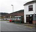
1
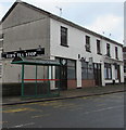
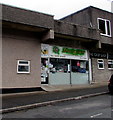
Ted's Tea Stop, Abercarn
Cafe at 1 & 2 Price's Row, High Street, Abercarn.
Image: © Jaggery
Taken: 14 Jan 2017
0.01 miles
2
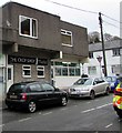
Ted's Tea Stop, Abercarn
Cafe at 1 & 2 Price's Row, High Street, Abercarn.
Image: © Jaggery
Taken: 14 Jan 2017
0.01 miles
3
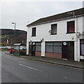
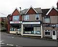
Hairlines in Abercarn
Hair & beauty salon at 3 Victoria Buildings, High Street.
Image: © Jaggery
Taken: 14 Jan 2017
0.01 miles
4
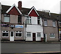
The Crop Shop, Abercarn
Hair & beauty salon viewed across Bridge Street.
Image: © Jaggery
Taken: 14 Jan 2017
0.01 miles
5
Knights, Bridge Street, Abercarn
The DIY, pets and gardening supplies shop also sells fresh fruit & vegetables.
Image: © Jaggery
Taken: 14 Jan 2017
0.01 miles
6
Evans Pharmacy, Abercarn
Located in Victoria Buildings, 1 & 2 High Street.
Image: © Jaggery
Taken: 14 Jan 2017
0.01 miles
7
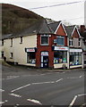
Evans times three, Abercarn Pharmacy, High Street, Abercarn
The three occurrences of the name Evans are in a font size
several times larger than the name Abercarn Pharmacy above each Evans.
Image: © Jaggery
Taken: 14 Jan 2017
0.01 miles
8
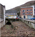
Tunnel under High Street, Abercarn
My first thought on seeing this tunnel was that the land in front of it is a dry watercourse. Maps show that this is part of a 180 metre break in the surface course of the brook named Nant Gwyddon, a tributary of the Ebbw River.
Image: © Jaggery
Taken: 14 Jan 2017
0.01 miles
9
High Street bus stop and shelter, Abercarn
This side of the road for buses to Newbridge and Blackwood. Ted's Tea Stop cafe http://www.geograph.org.uk/photo/5256697 is on the right.
Image: © Jaggery
Taken: 14 Jan 2017
0.01 miles
10
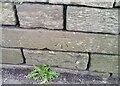
Ordnance Survey Cut Mark
This OS cut mark can be found on the wall west side of High Street. It marks a point 100.279m above mean sea level.
Image: © Adrian Dust
Taken: 16 Aug 2021
0.01 miles