IMAGES TAKEN NEAR TO
Newbridge, NEWPORT, NP11 5FF
Introduction
This page details the photographs taken nearby to NP11 5FF by members of the Geograph project.
The Geograph project started in 2005 with the aim of publishing, organising and preserving representative images for every square kilometre of Great Britain, Ireland and the Isle of Man.

There are currently over 7.5m images from over14,400 individuals and you can help contribute to the project by visiting https://www.geograph.org.uk
Image Map
Images are licensed for reuse under creativecommons.org/licenses/by-sa/2.0
Notes
- Clicking on the map will re-center to the selected point.
- The higher the marker number, the further away the image location is from the centre of the postcode.
Image Listing (288 Images Found)
Images are licensed for reuse under creativecommons.org/licenses/by-sa/2.0
Image
Details
Distance
1
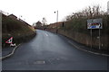
North along North Road, Newbridge
A sign on the right points this way towards Crumlin (Crymlyn in Welsh).
A railway perimeter wall is on the right. Newbridge railway station is behind the camera.
Image: © Jaggery
Taken: 14 Jan 2017
0.02 miles
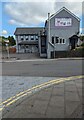
2
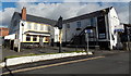
Goldmine for sale in Newbridge
At the early January 2014 date of this view, there was an
INVESTMENT FOR SALE board on a wall of the former Goldmine pub in Bridge Street.
Image: © Jaggery
Taken: 9 Jan 2014
0.02 miles
3
Chou Chous Day Nursery in Newbridge
Viewed across Bridge Street in January 2017.
The building was formerly the Goldmine pub, seen here http://www.geograph.org.uk/photo/3809122 in January 2014.
Image: © Jaggery
Taken: 14 Jan 2017
0.02 miles
4
North Road junction, Newbridge
Maps show both roads as North Road. The road on the left descends towards this http://www.geograph.org.uk/photo/5253230 railway bridge.
Image: © Jaggery
Taken: 14 Jan 2017
0.03 miles
5
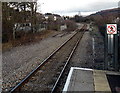
North from Newbridge railway station
Alongside a disconnected track ahead, the single track line crosses Bridge Street bridge. http://www.geograph.org.uk/photo/1931451
The location of the bridge is shown by the darker colour between ballast.
The next station ahead is Llanhilleth, then the terminus at Ebbw Vale Parkway.
Image: © Jaggery
Taken: 9 Jan 2014
0.03 miles
6
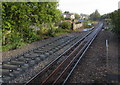
Railway north from Newbridge railway station
The railway crosses Bridge Street bridge ahead. Viewed in September 2015, when work on doubling the track between Crosskeys Junction and Aberbeeg Junction has begun. When complete, the double track will enable a more frequent service on the Ebbw Vale line, currently a maximum of one train per hour in each direction.
Image: © Jaggery
Taken: 18 Sep 2015
0.03 miles
7
Day Nursery, Bridge Street, Newbridge
The south side of Chou Chous Day Nursery in July 2023.
Image: © Jaggery
Taken: 19 Jul 2023
0.03 miles
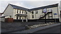
8

Chou Chous Day Nursery name sign, Newbridge
Located here https://www.geograph.org.uk/photo/7545675 in July 2023.
Image: © Jaggery
Taken: 19 Jul 2023
0.03 miles
9

Chou Chous Day Nursery name sign, Newbridge
Located here. http://www.geograph.org.uk/photo/5253178 The frame formerly held the name sign for the Goldmine pub.
Image: © Jaggery
Taken: 14 Jan 2017
0.03 miles
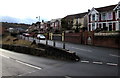
10
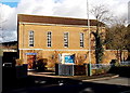
Newbridge Methodist Church
Viewed across Bridge Street, Newbridge.
Image: © Jaggery
Taken: 9 Jan 2014
0.04 miles