IMAGES TAKEN NEAR TO
Keir Hardie Terrace, NEWPORT, NP11 5EL
Introduction
This page details the photographs taken nearby to Keir Hardie Terrace, NP11 5EL by members of the Geograph project.
The Geograph project started in 2005 with the aim of publishing, organising and preserving representative images for every square kilometre of Great Britain, Ireland and the Isle of Man.

There are currently over 7.5m images from over14,400 individuals and you can help contribute to the project by visiting https://www.geograph.org.uk
Image Map
Images are licensed for reuse under creativecommons.org/licenses/by-sa/2.0
Notes
- Clicking on the map will re-center to the selected point.
- The higher the marker number, the further away the image location is from the centre of the postcode.
Image Listing (71 Images Found)
Images are licensed for reuse under creativecommons.org/licenses/by-sa/2.0
Image
Details
Distance
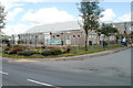
1
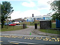
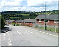
Sofrydd Primary School
Located on the north side of Sofrydd Road (B4471), NW of the community centre. http://www.geograph.org.uk/photo/2635067
Image: © Jaggery
Taken: 29 Jun 2011
0.02 miles
2
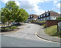
Gordon Avenue, Sofrydd
Houses on the SE side of Gordon Avenue, viewed across Sofrydd Road (B4471).
Image: © Jaggery
Taken: 29 Jun 2011
0.06 miles
4
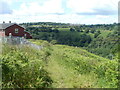
Track near Keir Hardie Terrace, Sofrydd
A track descends from Sofrydd Road (B4471) past the edge of Keir Hardie Terrace houses.
Image: © Jaggery
Taken: 29 Jun 2011
0.07 miles
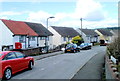
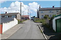
5
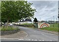
Keir Hardie Terrace, Sofrydd
Viewed from the Sofrydd Road (B4471) end.
Image: © Jaggery
Taken: 29 Jun 2011
0.07 miles
6
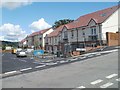
Recently-built housing, Sofrydd
Clos Ysgol Bron-y-bran is located on the south side of the B4471, on a site formerly occupied by a school.
Image: © Jaggery
Taken: 29 Jun 2011
0.07 miles
7
Lloyd Avenue, Sofrydd
Houses at the eastern end of the avenue, viewed from the corner of Walters Avenue.
Image: © Jaggery
Taken: 29 Jun 2011
0.08 miles
9
Road from Lewis Street to the B4471, Sofrydd
An unnamed road ascends from roughly the midpoint of Lewis Street, towards the B4471, 150 metres away.
Image: © Jaggery
Taken: 29 Jun 2011
0.11 miles
10
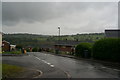
Sofrydd Community Centre
Located on the corner of Walters Avenue and Sofrydd Road (B4471).
Image: © Jaggery
Taken: 29 Jun 2011
0.11 miles