IMAGES TAKEN NEAR TO
Stonerwood View, NEWPORT, NP11 5DF
Introduction
This page details the photographs taken nearby to Stonerwood View, NP11 5DF by members of the Geograph project.
The Geograph project started in 2005 with the aim of publishing, organising and preserving representative images for every square kilometre of Great Britain, Ireland and the Isle of Man.

There are currently over 7.5m images from over14,400 individuals and you can help contribute to the project by visiting https://www.geograph.org.uk
Image Map
Images are licensed for reuse under creativecommons.org/licenses/by-sa/2.0
Notes
- Clicking on the map will re-center to the selected point.
- The higher the marker number, the further away the image location is from the centre of the postcode.
Image Listing (21 Images Found)
Images are licensed for reuse under creativecommons.org/licenses/by-sa/2.0
Image
Details
Distance
1

Carlyon Road, Pantside
Viewed from Old Pant Road. Pantside is a residential area adjacent to Newbridge.
Image: © Jaggery
Taken: 16 Aug 2010
0.07 miles
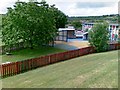
2

Bungalows, Stonerwood View, Pantside
There are no houses on the west side of Stonerwood View for about 70 metres from the junction with Old Pant Road. That area is the eastern perimeter of Pantside Infants and Junior Schools. The edge of the school railings are visible.
Pantside is a residential area adjacent to Newbridge.
Image: © Jaggery
Taken: 16 Aug 2010
0.07 miles
4

Entrance to Pantside Junior and Infants School
Viewed across Old Pant Road.
Image: © Jaggery
Taken: 16 Aug 2010
0.12 miles
5

Eastern side of Old Pant Road, Pantside
Old Pant Road houses between St Peters Close and Newlyn Road. Pantside is a residential area adjacent to Newbridge.
Image: © Jaggery
Taken: 16 Aug 2010
0.12 miles
6

Newlyn Road, Pantside
Viewed across Old Pant Road. Pantside is a residential area adjacent to Newbridge.
Image: © Jaggery
Taken: 16 Aug 2010
0.14 miles
7
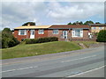
Bungalows, Old Pant Road, Pantside
The bungalows are located on the section of Old Pant Road between Claremont Road and Coronation Crescent. Pantside is a residential area adjacent to Newbridge.
Image: © Jaggery
Taken: 16 Aug 2010
0.15 miles
8
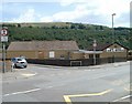
Pant Social Club & Institute
Located on the corner of St Peters Close and Old Pant Road, opposite a roundabout.
Image: © Jaggery
Taken: 16 Aug 2010
0.18 miles
9
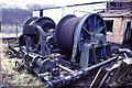
Celynen North Colliery
Now flat. Rope-changing capstan by Uskside Engineering Co, Newport, 1911. Was workable on compressed air. Scrapped 1988. This particular trip concentrated entirely on the capstan. I don't know if I have any overviews from another trip but if I find any I will post them.
Image: © Chris Allen
Taken: 8 Feb 1987
0.18 miles
10
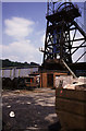
Celynen North Pit
This shows the headgear and the compressed air rope changing winch at its foot. Nearby Celynen South was already flat and it has now been joined by the North Pit.
Image: © Chris Allen
Taken: 4 Jul 1987
0.18 miles