IMAGES TAKEN NEAR TO
Crumlin, NEWPORT, NP11 5BR
Introduction
This page details the photographs taken nearby to NP11 5BR by members of the Geograph project.
The Geograph project started in 2005 with the aim of publishing, organising and preserving representative images for every square kilometre of Great Britain, Ireland and the Isle of Man.

There are currently over 7.5m images from over14,400 individuals and you can help contribute to the project by visiting https://www.geograph.org.uk
Image Map
Images are licensed for reuse under creativecommons.org/licenses/by-sa/2.0
Notes
- Clicking on the map will re-center to the selected point.
- The higher the marker number, the further away the image location is from the centre of the postcode.
Image Listing (11 Images Found)
Images are licensed for reuse under creativecommons.org/licenses/by-sa/2.0
Image
Details
Distance
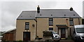
1
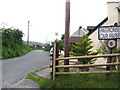
Public House at Cefn-Crib
This is a very small hamlet, with this pub.
Image: © Jessica Aidley
Taken: 6 Jul 2007
0.06 miles
2
Ruins of Ty-pwll farm
The remains of the farm buildings and the stone wall bordering the farm track from Cefn-crib Road can still be seen.
Image: © M J Roscoe
Taken: 6 Mar 2016
0.08 miles
3
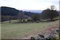
Farmland near Cefn-y-crib
Farmland near Cefn-y-crib above Cwm y Glyn, among the trees are the ruins of a farm and cottages called Ty-Pwll.
Image: © Philip Halling
Taken: 10 Aug 2012
0.10 miles
4
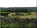
Beech hedge and dry stone wall.
In this picture you can see three main ways of keeping stock in a field:- there is barbed wire, a dry stone wall and an old beech hedge, which had been allowed to become overgrown, but which is now being cared for. The wire on this side of the wall may be there to stop people climbing over the wall. People who are not familiar with dry stone walls do not realise that climbing over them often damages them, because stones become dislodged from the top, and then the rest of the wall is easily knocked down. The tall trees in the distance look as though they were once 'laid' into a hedge but have been allowed to grow into trees.
Image: © Jessica Aidley
Taken: 6 Jul 2007
0.14 miles
5
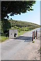
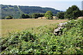
Cattle grid on Cefn-Grib Road
Cattle grid on Cefn-Grib Road which the road enters open grazing land.
Image: © Philip Halling
Taken: 10 Aug 2012
0.16 miles
7
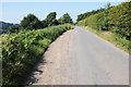
Cefn-crib Road
Country road high above Cwm y Glyn.
Image: © Philip Halling
Taken: 10 Aug 2012
0.19 miles
8
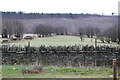
Pasture, Cefn-crib Road
Upland pasture above Cwm y Clyn. The bare multi-stemmed beech trees would at one time have formed a hedgerow, but this green boundary has not been maintained. Across the valley, the conifers in Coedcae Watkin Dafydd were clear felled in 2015. Taken from next to the cattle grid in Image
Image: © M J Roscoe
Taken: 6 Mar 2016
0.20 miles
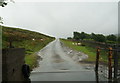
10
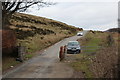
Cattle grid, Cefn-crib Road
The white car is approaching from Pantygaseg across the open moor.
Image: © M J Roscoe
Taken: 6 Mar 2016
0.21 miles