IMAGES TAKEN NEAR TO
Herbert Street, NEWPORT, NP11 5BD
Introduction
This page details the photographs taken nearby to Herbert Street, NP11 5BD by members of the Geograph project.
The Geograph project started in 2005 with the aim of publishing, organising and preserving representative images for every square kilometre of Great Britain, Ireland and the Isle of Man.

There are currently over 7.5m images from over14,400 individuals and you can help contribute to the project by visiting https://www.geograph.org.uk
Image Map
Images are licensed for reuse under creativecommons.org/licenses/by-sa/2.0
Notes
- Clicking on the map will re-center to the selected point.
- The higher the marker number, the further away the image location is from the centre of the postcode.
Image Listing (71 Images Found)
Images are licensed for reuse under creativecommons.org/licenses/by-sa/2.0
Image
Details
Distance
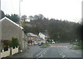
1
Bench, phonebox and speed camera sign, Hafodyrynys
On a long narrow island between a side road and the A472 on the right.
Image: © Jaggery
Taken: 8 Sep 2017
0.03 miles
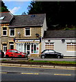
2

Herbert Street, Hafodyrynys
Herbert Street is a row of 20 houses on the south side of the A472.
Image: © Jaggery
Taken: 16 Aug 2010
0.03 miles
3

Hafodyrynys : Last house on the north side of the A472
Looking eastwards along the A472. On the other side of the road is a long row of houses, http://www.geograph.org.uk/photo/2020970 but on this side of the road, the only building after this one is the chapel http://www.geograph.org.uk/photo/2017859 and then the A472 becomes a rural road until it reaches the outskirts of Pontypool.
Image: © Jaggery
Taken: 16 Aug 2010
0.03 miles
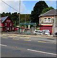
4
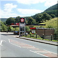
Hafodyrynys service station and convenience store
Located alongside the A472, at the eastern end of Hafodyrynys, a small village in the County Borough of Caerphilly.
Image: © Jaggery
Taken: 16 Aug 2010
0.04 miles
5
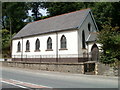
Hafodyrynys Congregational Chapel
Located alongside the A472 at the eastern end of the small village of Hafodyrynys.
There was nothing visible on the church to identify it, but it looks like it has recently been painted, so perhaps the name board is about to be reinstated.
Image: © Jaggery
Taken: 16 Aug 2010
0.04 miles
6
Breakfast in Bread, Hafodyrynys
Takeaway selling baguettes, sandwiches, jacket potatoes etc located in the middle of a short row of shops alongside a side road set back from the north side of the A472.
Image: © Jaggery
Taken: 8 Sep 2017
0.04 miles
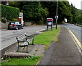
7
Hafodyrynys bus stop and shelter
On the north side of the A472. In early September 2017 the timetable in the shelter shows that this is a stop on three bus routes - 21 to Pontypool and Cwmbran via Old Furnace and X22 to Pontypool, both operated by Stagecoach. The third route is X1 to Cwmbran via Pontypool and Croesyceiliog operated by Phil Anslow Coaches. The Hafodyrynys Inn is http://www.geograph.org.uk/photo/5529536on the left.
Image: © Jaggery
Taken: 8 Sep 2017
0.05 miles
8
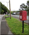
Queen Elizabeth II postbox, Hafodyrynys
In need of a repaint in early September 2017. The makers' name
embossed on the bottom of the box is CARRON COMPANY STIRLINGSHIRE.
Image: © Jaggery
Taken: 8 Sep 2017
0.05 miles
9
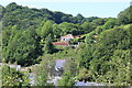
Hillside bungalow, Hafodyrynys
Bungalow, on driveway off Cefn Crib Road, above A472.
Image: © M J Roscoe
Taken: 13 Jun 2021
0.05 miles