IMAGES TAKEN NEAR TO
Hafodyrynys, Crumlin, NEWPORT, NP11 5AY
Introduction
This page details the photographs taken nearby to NP11 5AY by members of the Geograph project.
The Geograph project started in 2005 with the aim of publishing, organising and preserving representative images for every square kilometre of Great Britain, Ireland and the Isle of Man.

There are currently over 7.5m images from over14,400 individuals and you can help contribute to the project by visiting https://www.geograph.org.uk
Image Map
Images are licensed for reuse under creativecommons.org/licenses/by-sa/2.0
Notes
- Clicking on the map will re-center to the selected point.
- The higher the marker number, the further away the image location is from the centre of the postcode.
Image Listing (3 Images Found)
Images are licensed for reuse under creativecommons.org/licenses/by-sa/2.0
Image
Details
Distance
1

Pylon alongside Hafodyrynys to Pantside country road
After several hundred metres of country road which has climbed steadily through woodland, from the A472 in Hafodyrynys, a gap in the trees reveals a pylon, and power lines crossing the road.
Image: © Jaggery
Taken: 16 Aug 2010
0.24 miles
2

Woodland track south of Hafodyrynys
A track heads away eastwards from the road to Pantside, through woodland south of Hafodyrynys.
Image: © Jaggery
Taken: 16 Aug 2010
0.24 miles
3
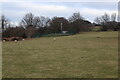
Reservoir above Pantside
Small covered reservoir at the side of a field.
Image: © M J Roscoe
Taken: 20 Mar 2021
0.24 miles