IMAGES TAKEN NEAR TO
Coed Celynen Drive, NEWPORT, NP11 5AU
Introduction
This page details the photographs taken nearby to Coed Celynen Drive, NP11 5AU by members of the Geograph project.
The Geograph project started in 2005 with the aim of publishing, organising and preserving representative images for every square kilometre of Great Britain, Ireland and the Isle of Man.

There are currently over 7.5m images from over14,400 individuals and you can help contribute to the project by visiting https://www.geograph.org.uk
Image Map
Images are licensed for reuse under creativecommons.org/licenses/by-sa/2.0
Notes
- Clicking on the map will re-center to the selected point.
- The higher the marker number, the further away the image location is from the centre of the postcode.
Image Listing (20 Images Found)
Images are licensed for reuse under creativecommons.org/licenses/by-sa/2.0
Image
Details
Distance
1
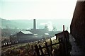
Celynen South Colliery, Newbridge ? 1969
Exhaust steam rises from the winding engines. Classic Welsh valleys mining scenery.
Image: © Alan Murray-Rust
Taken: 25 Nov 1969
0.03 miles
2
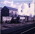
Celynen South Pit
In the days when little steam engines pulled trains of trucks round pit yards. Andrew Barclay tank engine no 1608/1918 with the driver looking out, evidently enjoying himself.
Image: © Paul Brown
Taken: 6 Mar 1970
0.05 miles
3
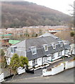
Cul-de-sac off Coed Celynen Drive
New houses on housing estate on site of former Celynen Collieries, viewed from a lay-by on the A467.
Image: © M J Roscoe
Taken: 22 Nov 2018
0.07 miles
4
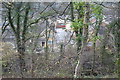
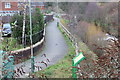
Derelict section of canal, near Abercarn
Dry section of the Crumlin Arm of the Mon & Brec Canal below the A467. A puddle of water can just be seen at bottom right.
Image: © M J Roscoe
Taken: 22 Nov 2018
0.10 miles
5
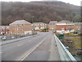
Coed Celynen, Abercarn
The view west from a bridge across the Ebbw River, about 70 metres west of the A467/B4591 roundabout. The Coed Celynen housing development occupies the site of the former South Celynen colliery.
Image: © Jaggery
Taken: 23 Jan 2011
0.10 miles
6
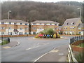
Houses, Mill Race, Coed Celynen, Abercarn
Recently-built houses on Mill Race, part of the Coed Celynen development on the site of the former South Celynen colliery. Viewed along the access road from the A467.
Image: © Jaggery
Taken: 23 Jan 2011
0.10 miles
7
View from a footbridge, Abercarn
The view NW from an A467 footbridge. http://www.geograph.org.uk/photo/2295819
In the middle distance are recently-built houses in Coed Celynen, a housing development on the site of the former South Celynen colliery.
Image: © Jaggery
Taken: 23 Jan 2011
0.10 miles
8
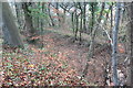
Riverside footpath, Coed Celynen Drive
Combined cycle and pedestrian path, between the housing estate and River Ebbw Image, to Newbridge.
Image: © M J Roscoe
Taken: 6 Jan 2019
0.11 miles
9
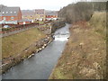
River Ebbw by Coed Celynen Drive
Looking upstream from bridge into housing estate.
Image: © M J Roscoe
Taken: 6 Jan 2019
0.12 miles
10
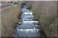
Ebbw River weir, Abercarn
The houses are on Coed Celynen Drive.
Image: © Jaggery
Taken: 23 Jan 2011
0.12 miles