IMAGES TAKEN NEAR TO
Darren Drive, Prince Of Wales Industrial Estate, NEWPORT, NP11 5AR
Introduction
This page details the photographs taken nearby to Darren Drive, Prince Of Wales Industrial Estate, NP11 5AR by members of the Geograph project.
The Geograph project started in 2005 with the aim of publishing, organising and preserving representative images for every square kilometre of Great Britain, Ireland and the Isle of Man.

There are currently over 7.5m images from over14,400 individuals and you can help contribute to the project by visiting https://www.geograph.org.uk
Image Map
Images are licensed for reuse under creativecommons.org/licenses/by-sa/2.0
Notes
- Clicking on the map will re-center to the selected point.
- The higher the marker number, the further away the image location is from the centre of the postcode.
Image Listing (65 Images Found)
Images are licensed for reuse under creativecommons.org/licenses/by-sa/2.0
Image
Details
Distance
1
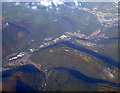
Abercarn from the air
Steep hills and longs shadows in this early autumn photo taken from a Bristol bound flight from Glasgow.
Image: © Thomas Nugent
Taken: 11 Oct 2010
0.03 miles
2
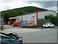
Post Office: Abercarn Royal Mail Sorting Office
Abercarn Royal Mail Sorting Office built 1994 on the site of the old Prince of Wales Colliery. Looking South-East towards Cefn Rhyswg
Image: © Phil White
Taken: 10 Jul 2006
0.03 miles
3
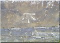
Ordnance Survey Cut Mark
This OS cut mark can be found on the wall east side of the road. It marks a point 93.254m above mean sea level.
Image: © Adrian Dust
Taken: 11 May 2019
0.04 miles
4
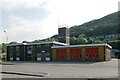
Abercarn Fire Station
Abercarn Fire Station, Darren Drive, Prince of Wales Industrial Estate, Abercarn, Newport
Image: © Kevin Hale
Taken: 4 Jun 2007
0.04 miles
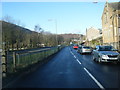
5

Davies Place, Abercarn
Side road and houses above the B4591 Commercial Road.
Image: © Jaggery
Taken: 20 Dec 2016
0.05 miles
7
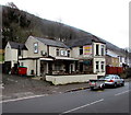
Rhyswg Bar & Grill, Abercarn
Viewed across the B4591 Commercial Road.
Image: © Jaggery
Taken: 20 Dec 2016
0.07 miles
8

King Edward VII postbox in a Commercial Road wall, Abercarn
On the left here. http://www.geograph.org.uk/photo/5245515
Image: © Jaggery
Taken: 20 Dec 2016
0.08 miles
10
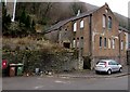
Derelict former chapel, Commercial Road, Abercarn
Viewed in December 2016. The name on the building is FULL GOSPEL MISSION.
Built as Commercial Road Methodist Chapel in 1875, rebuilt in 1900.
Image: © Jaggery
Taken: 20 Dec 2016
0.08 miles