IMAGES TAKEN NEAR TO
Commercial Road, NEWPORT, NP11 5AJ
Introduction
This page details the photographs taken nearby to Commercial Road, NP11 5AJ by members of the Geograph project.
The Geograph project started in 2005 with the aim of publishing, organising and preserving representative images for every square kilometre of Great Britain, Ireland and the Isle of Man.

There are currently over 7.5m images from over14,400 individuals and you can help contribute to the project by visiting https://www.geograph.org.uk
Image Map
Images are licensed for reuse under creativecommons.org/licenses/by-sa/2.0
Notes
- Clicking on the map will re-center to the selected point.
- The higher the marker number, the further away the image location is from the centre of the postcode.
Image Listing (45 Images Found)
Images are licensed for reuse under creativecommons.org/licenses/by-sa/2.0
Image
Details
Distance
1
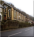
Edwardian Sunday School, Abercarn
The inscription http://www.geograph.org.uk/photo/5245460 on the English Baptist Church Sunday School shows the year 1904.
The edge of the English Baptist Church http://www.geograph.org.uk/photo/5245449 is on the left.
Both the Sunday school and the church are Grade II listed.
Image: © Jaggery
Taken: 20 Dec 2016
0.01 miles
2
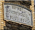
Inscription on a Sunday School wall, Abercarn
Located between two windows here. http://www.geograph.org.uk/photo/5245456
Image: © Jaggery
Taken: 20 Dec 2016
0.01 miles
3
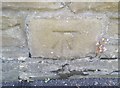
Ordnance Survey Cut Mark
This OS cut mark can be found on the wall of the chapel. It marks a point 95.220m above mean sea level.
Image: © Adrian Dust
Taken: 11 May 2019
0.02 miles
4
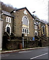
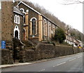
English Baptist Church, Abercarn
Viewed across Commercial Road. The building dates from 1857, remodelled in 1882.
The English part of its name indicates the language of worship in an area where
Welsh was widely spoken at that time. The building was Grade II listed in 1998.
Image: © Jaggery
Taken: 20 Dec 2016
0.02 miles
5
English Baptist Church Sunday School, Abercarn
Grade II listed building on Commercial Road, alongside the church http://www.geograph.org.uk/photo/2261932 which is also Grade II listed.
Image: © Jaggery
Taken: 7 Feb 2011
0.03 miles
6
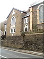
English Baptist Church, Abercarn
Grade II listed building on Commercial Road. The Sunday School, http://www.geograph.org.uk/photo/2261935 also Grade II listed, is on the right.
The boundary between Abercarn and Cwmcarn is unclear in this area. The church is on the Cwmcarn side of boundary signs on the adjacent A467.
Image: © Jaggery
Taken: 7 Feb 2011
0.03 miles
7
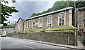
English Baptist Church, Abercarn
The English Baptist Church is a Grade II-listed Baptist church in the town of Abercarn, Caerphilly, Wales. It was built in the mid-nineteenth century to give the Baptists a church of their own. The building was extensively remodelled later in the century.
Image: © Alan Hughes
Taken: 12 Jun 2022
0.04 miles
8
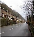
Houses above Commercial Road, Cwmcarn
The houses are at the edge of a hillside - Craig Llwyfas.
Image: © Jaggery
Taken: 20 Dec 2016
0.04 miles
9
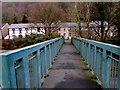
Across a footbridge to Commercial Road, Cwmcarn
From the A467 across this http://www.geograph.org.uk/photo/5245317 footbridge.
Image: © Jaggery
Taken: 20 Dec 2016
0.05 miles
10
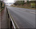
A467 towards a footbridge, Cwmcarn
Towards this footbridge. http://www.geograph.org.uk/photo/5245317 The sign on the right shows the way to the Prince of Wales Industrial Estate.
Image: © Jaggery
Taken: 20 Dec 2016
0.06 miles