IMAGES TAKEN NEAR TO
Park Place, NEWPORT, NP11 4RL
Introduction
This page details the photographs taken nearby to Park Place, NP11 4RL by members of the Geograph project.
The Geograph project started in 2005 with the aim of publishing, organising and preserving representative images for every square kilometre of Great Britain, Ireland and the Isle of Man.

There are currently over 7.5m images from over14,400 individuals and you can help contribute to the project by visiting https://www.geograph.org.uk
Image Map
Images are licensed for reuse under creativecommons.org/licenses/by-sa/2.0
Notes
- Clicking on the map will re-center to the selected point.
- The higher the marker number, the further away the image location is from the centre of the postcode.
Image Listing (206 Images Found)
Images are licensed for reuse under creativecommons.org/licenses/by-sa/2.0
Image
Details
Distance
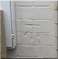
1
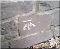
Ordnance Survey Cut Mark
This OS cut mark can be found on the wall west side of Park Road. It marks a point 141.564m above mean sea level.
Image: © Adrian Dust
Taken: 11 May 2019
0.10 miles
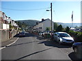
2
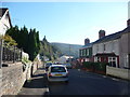
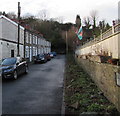
Part of Tynewydd Terrace, Newbridge
Tynewydd Terrace slopes down towards the High Street.
Image: © Jeremy Bolwell
Taken: 14 Oct 2012
0.11 miles
3
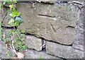
Ordnance Survey Cut Mark
This OS cut mark can be found on the NW side of Park Road. It marks a point 142.250m above mean sea level.
Image: © Adrian Dust
Taken: 11 May 2019
0.11 miles
4
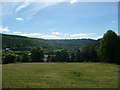
View from the top of Caetwmpyn Park, Newbridge
A park with pleasant views out over the valley southwards.
Image: © Jeremy Bolwell
Taken: 1 Jun 2013
0.12 miles
5
Ordnance Survey Cut Mark
This OS cut mark can be found on No31 Tynewydd Terrace. It marks a point 130.046m above mean sea level.
Image: © Adrian Dust
Taken: 11 May 2019
0.12 miles
6
Part of Tynewydd Terrace, Newbridge
A Welsh flag flies, or rather hangs limply today, on a flagpole here.
Image: © Jeremy Bolwell
Taken: 14 Oct 2012
0.12 miles
7
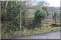
Stile, Ebbw Valley Walk, Newbridge
Overgrown stile from just off minor road to a little used public field footpath.
Image: © M J Roscoe
Taken: 4 Feb 2017
0.13 miles
8
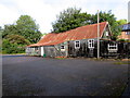
Rusty-roofed church hall, Newbridge
On the north side of St Paul's Church. http://www.geograph.org.uk/photo/4664730
Image: © Jaggery
Taken: 18 Sep 2015
0.15 miles
9
23-30 Alexandra Place, Newbridge
A dead street aligned east-west, at right angles to the main course of Alexandra Place.
Image: © Jaggery
Taken: 14 Jan 2017
0.15 miles
10
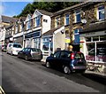
Cars and shops, Tynewydd Terrace, Newbridge
Viewed from the corner of High Street. Double yellow lines on the left side of the street
indicate no parking at any time whereas on-street parking is much in evidence on the right side.
Image: © Jaggery
Taken: 18 Sep 2015
0.15 miles