IMAGES TAKEN NEAR TO
Ashfield Road, NEWPORT, NP11 4RA
Introduction
This page details the photographs taken nearby to Ashfield Road, NP11 4RA by members of the Geograph project.
The Geograph project started in 2005 with the aim of publishing, organising and preserving representative images for every square kilometre of Great Britain, Ireland and the Isle of Man.

There are currently over 7.5m images from over14,400 individuals and you can help contribute to the project by visiting https://www.geograph.org.uk
Image Map
Images are licensed for reuse under creativecommons.org/licenses/by-sa/2.0
Notes
- Clicking on the map will re-center to the selected point.
- The higher the marker number, the further away the image location is from the centre of the postcode.
Image Listing (63 Images Found)
Images are licensed for reuse under creativecommons.org/licenses/by-sa/2.0
Image
Details
Distance
1
Tynewydd Primary School, Newbridge
Primary school with about 250 pupils,viewed across a street named Greenfield.
Image: © Jaggery
Taken: 17 Feb 2011
0.05 miles
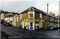
2
North along Greenfield, Newbridge
From Ashfield Road. Greenfield Stores http://www.geograph.org.uk/photo/5254078 are on the left.
Image: © Jaggery
Taken: 14 Jan 2017
0.06 miles
3
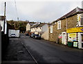
Ashfield Road, Newbridge
Looking NW along Ashfield Road from the Greenfield junction. Greenfield Stores http://www.geograph.org.uk/photo/5254078 are on the right.
Image: © Jaggery
Taken: 14 Jan 2017
0.08 miles
4
Nursery, Tynewydd Primary School
The nursery building is located on Greenfield, at the northern edge (and highest point) of the primary school http://www.geograph.org.uk/photo/2273660 site.
Image: © Jaggery
Taken: 17 Feb 2011
0.09 miles
5
Greenfield Stores, Newbridge
Premier Express convenience store at number 1 Greenfield, on the corner of Ashfield Road.
Image: © Jaggery
Taken: 14 Jan 2017
0.10 miles
6
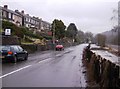
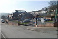
Older housing at Newbridge
On the road from Newbridge to Crumlin in the western part of the square. These older houses are built up away from the road. To the right is the Ebbw Vale railway line, shortly to reopen to passengers.
Image: © Graham Horn
Taken: 28 Dec 2007
0.10 miles
7
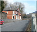
The Masons Arms, Newbridge
Located on North Road, the road to Crumlin. The fence is the perimeter of the Ebbw Valley railway.
There has been a pub or inn on this site since the early days of Newbridge. An 1846 map shows the Blacksmiths Arms on the same site.
At the side of the pub, a steep, unnamed, road http://www.geograph.org.uk/photo/2274051 gives pedestrians access between North Road and Greenfield.
Image: © Jaggery
Taken: 17 Feb 2011
0.10 miles
8
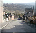
Steep descent from Greenfield, Newbridge
The view from the edge of Greenfield down a steep, unnamed, road giving pedestrians access to North Road. Metal railings prevent vehicular access.
The building at the foot of the hill on the left is the Masons Arms. http://www.geograph.org.uk/photo/2274065
Image: © Jaggery
Taken: 17 Feb 2011
0.10 miles
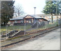
9
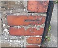
Ordnance Survey Cut Mark
This OS cut mark can be found on the wall of No43 North Road. It marks a point 113.023m above mean sea level.
Image: © Adrian Dust
Taken: 11 May 2019
0.11 miles
10
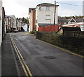
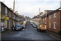
No parking in Ashfield Road, Newbridge
Double yellow lines on both sides indicate no parking at any time.
Image: © Jaggery
Taken: 14 Jan 2017
0.11 miles