IMAGES TAKEN NEAR TO
Newbridge By-Pass, NEWPORT, NP11 4QJ
Introduction
This page details the photographs taken nearby to Newbridge By-Pass, NP11 4QJ by members of the Geograph project.
The Geograph project started in 2005 with the aim of publishing, organising and preserving representative images for every square kilometre of Great Britain, Ireland and the Isle of Man.

There are currently over 7.5m images from over14,400 individuals and you can help contribute to the project by visiting https://www.geograph.org.uk
Image Map (Loading...)


Getting Data...Please wait
Leaflet Map data © OpenStreetMap
Images are licensed for reuse under creativecommons.org/licenses/by-sa/2.0
Notes
- Clicking on the map will re-center to the selected point.
- The higher the marker number, the further away the image location is from the centre of the postcode.
Image Listing (62 Images Found)
Images are licensed for reuse under creativecommons.org/licenses/by-sa/2.0
Image
Details
Distance
1
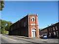
Crumlin Workmen's Club and Institute
Dated 1920 but now used by a training company for training care workers I believe.
Image: © Jeremy Bolwell
Taken: 14 Oct 2012
0.12 miles
2
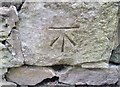
Ordnance Survey Cut Mark
This OS cut mark can be found on the wall SE side of North Road. It marks a point 109.167m above mean sea level.
Image: © Adrian Dust
Taken: 11 May 2019
0.12 miles
3
Old Mill in Crumlin
An interesting shape, taking the position at a road junction.
Image: © Graham Horn
Taken: 28 Dec 2007
0.13 miles
4
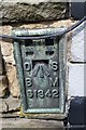
Ordnance Survey Flush Bracket (S1342)
This OS Flush Bracket can be found on the Old Police House, Crown Street. It marks a point 113.776m above mean sea level.
Image: © Adrian Dust
Taken: 11 May 2019
0.13 miles
5
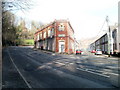
Marlan Day Centre, Crumlin
Located on the corner of Main Street (on the left) and Crown Street.
The building is the former Crumlin Workmen's Club and Institute. The year 1920 is inscribed in stone near roof level above the doorway.
Image: © Jaggery
Taken: 17 Feb 2011
0.13 miles
7
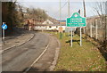
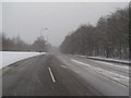
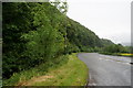
Southern boundary of Crumlin
Viewed along North Road from the northern edge of Newbridge.
Crumlin, population about 6,000, is a town in Caerphilly County Borough.
Image: © Jaggery
Taken: 17 Feb 2011
0.14 miles
8
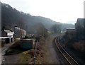
Crumlin : Bend ahead on the Ebbw Valley Line
Viewed from a footbridge. http://www.geograph.org.uk/photo/2713163
The next station in this direction is Newbridge. The houses are on Station Road.
There is no longer a railway station in Crumlin : the Low Level and High Level stations closed in the 1960s.
Image: © Jaggery
Taken: 17 Feb 2011
0.16 miles
9
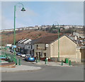
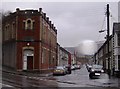
Main Street shops, Crumlin
Beyond green lampposts and posts is a row of shops and business premises on Main Street. Nearest the camera is The Wexa. http://www.geograph.org.uk/photo/2297484
Image: © Jaggery
Taken: 17 Feb 2011
0.16 miles