IMAGES TAKEN NEAR TO
Hillside Road, NEWPORT, NP11 4QB
Introduction
This page details the photographs taken nearby to Hillside Road, NP11 4QB by members of the Geograph project.
The Geograph project started in 2005 with the aim of publishing, organising and preserving representative images for every square kilometre of Great Britain, Ireland and the Isle of Man.

There are currently over 7.5m images from over14,400 individuals and you can help contribute to the project by visiting https://www.geograph.org.uk
Image Map
Images are licensed for reuse under creativecommons.org/licenses/by-sa/2.0
Notes
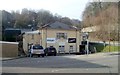
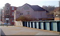
- Clicking on the map will re-center to the selected point.
- The higher the marker number, the further away the image location is from the centre of the postcode.
Image Listing (132 Images Found)
Images are licensed for reuse under creativecommons.org/licenses/by-sa/2.0
Image
Details
Distance
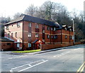
1
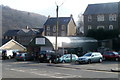
Crumlin RFC club and headquarters
Premises of Crumlin Rugby Football Club, located on the corner of Main Road and Kendon Road. Crumlin Rugby Football Club was founded in 1880.
Image: © Jaggery
Taken: 17 Feb 2011
0.02 miles
2
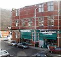
Crumlin Cafe and Crumlin Newsagents & Convenience Store, Crumlin Square, Crumlin
Two businesses occupying part of Institute Buildings. Another occupier, on the Main Road side, is the Adult and Youth Community Education Centre. http://www.geograph.org.uk/photo/2713002
Image: © Jaggery
Taken: 17 Feb 2011
0.02 miles
3
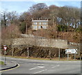
House on a hill, Crumlin
Sunny Croft is located on Load of Hay Road, behind and above the junction of Main Street and Kendon Road (B4251).
The sign points left along the B4251 for Oakdale, Trinant, Treowen and Pen-y-fan Pond. It points right for Newport, Brynwawr, Pontypool and Ebbw Vale.
Image: © Jaggery
Taken: 17 Feb 2011
0.02 miles
4
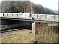
Western side of Kendon Road bridge, Crumlin
Viewed from a footbridge. http://www.geograph.org.uk/photo/2713163
This part of the bridge crosses over the single-track Ebbw Valley line, between Newbridge and Llanhilleth stations. The eastern side of the bridge http://www.geograph.org.uk/photo/2751339 crosses the River Ebbw.
Image: © Jaggery
Taken: 17 Feb 2011
0.02 miles
5
The Railway Hotel and Institute Buildings, Crumlin
This view, across a footbridge, http://www.geograph.org.uk/photo/2713163 shows the back of The Railway Hotel and an edge of Institute Buildings. http://www.geograph.org.uk/photo/2713011
Image: © Jaggery
Taken: 17 Feb 2011
0.02 miles
6
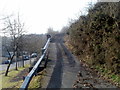
Load of Hay Road, Crumlin
Load of Hay Road climbs towards Sunny Croft. http://www.geograph.org.uk/photo/2713096 The B4251 (Kendon Road) is on the left.
Image: © Jaggery
Taken: 17 Feb 2011
0.02 miles
7
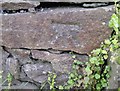
Ordnance Survey Cut Mark
This OS cut mark can be found on the wall south side of Hillside. It marks a point 146.301m above mean sea level.
Image: © Adrian Dust
Taken: 11 May 2019
0.03 miles
8
Ty Derwen residential care home, Crumlin
Located near the southern end of Kendon Road (B4251), Ty Derwen accommodates 32 residents (24 single and 4 shared rooms). It was purpose built in 1988.
Image: © Jaggery
Taken: 17 Feb 2011
0.05 miles
9
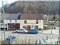
Old Barn Garage, Crumlin
Located on Kendon Road (B4251). The garage provides motor vehicle servicing & repair, and MoT preparation.
Image: © Jaggery
Taken: 17 Feb 2011
0.05 miles
10
The Wexa and Crumlin Balti, Main Street, Crumlin
Two of the premises on Main Street. http://www.geograph.org.uk/photo/2297475
The Wexa club is at 3 Main Street. An old photo shows that the premises were occupied by the Viaduct Tavern in 1908. Next door is Crumlin Balti.
Image: © Jaggery
Taken: 17 Feb 2011
0.05 miles