IMAGES TAKEN NEAR TO
Pennar Lane, NEWPORT, NP11 4GZ
Introduction
This page details the photographs taken nearby to Pennar Lane, NP11 4GZ by members of the Geograph project.
The Geograph project started in 2005 with the aim of publishing, organising and preserving representative images for every square kilometre of Great Britain, Ireland and the Isle of Man.

There are currently over 7.5m images from over14,400 individuals and you can help contribute to the project by visiting https://www.geograph.org.uk
Image Map
Images are licensed for reuse under creativecommons.org/licenses/by-sa/2.0
Notes
- Clicking on the map will re-center to the selected point.
- The higher the marker number, the further away the image location is from the centre of the postcode.
Image Listing (48 Images Found)
Images are licensed for reuse under creativecommons.org/licenses/by-sa/2.0
Image
Details
Distance
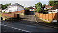
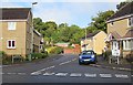
1

Woodside Drive, Newbridge
Housing on the corner of Woodside Drive, viewed across Bryngwyn Road. This is part of Pennar Heights, a Barratt Homes development of 1, 2, 3, 4 & 5 bedroom semi detached and detached houses.
Image: © Jaggery
Taken: 24 Jan 2011
0.04 miles
2
Cul-de-sac arm of New Bryngwyn Road, Newbridge
On the SW side of the main route of New Bryngwyn Road.
Image: © Jaggery
Taken: 18 Sep 2015
0.04 miles
3
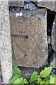
Ordnance Survey Cut Mark
This OS cut mark can be found on the wall at the road junction. It marks a point 137.867m above mean sea level.
Image: © Adrian Dust
Taken: 11 May 2019
0.07 miles
4
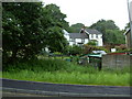
Bryngwyn Cottages
Until recently these cottages were surrounded by fields and woodland, now they have new houses being built on three sides.
Image: © Sally Lloyd
Taken: 5 Jul 2007
0.07 miles
5
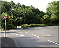
Ildiwch/Give Way sign in Newbridge
The bilingual (Welsh/English) sign is at the southern end of New Bryngwyn Road, at the Bryngwyn Road junction.
Image: © Jaggery
Taken: 18 Sep 2015
0.08 miles
6
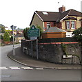
Western boundary of Newbridge
The boundary sign is on the corner of New Bryngwyn Road and Bryngwyn Road.
In 2015 part of the county borough of Caerphilly, Newbridge was historically part of Monmouthshire.
The Welsh name for this town is incorrectly shown on some maps as Cefn Bychan.
The sign shows that this Newbridge's Welsh name is Trecelyn, which literally means town of holly (trees).
Image: © Jaggery
Taken: 18 Sep 2015
0.08 miles
7
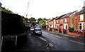
West along Bryngwyn Road, Newbridge
From the corner of Halls Road near the western edge of Newbridge.
Image: © Jaggery
Taken: 18 Sep 2015
0.08 miles
8
Woodside Drive, Newbridge
Viewed across New Bryngwyn Road.
Image: © Jaggery
Taken: 18 Sep 2015
0.09 miles
9
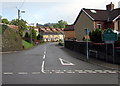
New Bryngwyn Road, Newbridge
New Bryngwyn Road heads north away from Bryngwyn Road and the Newbridge
(Trecelyn in Welsh) boundary sign, below which a sign shows 1½ (miles) to Crumlin.
Image: © Jaggery
Taken: 18 Sep 2015
0.10 miles
10

Corrugated metal buildings near Bryngwyn Road, Newbridge
My first thought was that these are lockup garages, but the depth of vegetation
and the alignment of the green structure suggest they may be sheds.
Image: © Jaggery
Taken: 18 Sep 2015
0.10 miles