IMAGES TAKEN NEAR TO
Bryngwyn Road, NEWPORT, NP11 4GX
Introduction
This page details the photographs taken nearby to Bryngwyn Road, NP11 4GX by members of the Geograph project.
The Geograph project started in 2005 with the aim of publishing, organising and preserving representative images for every square kilometre of Great Britain, Ireland and the Isle of Man.

There are currently over 7.5m images from over14,400 individuals and you can help contribute to the project by visiting https://www.geograph.org.uk
Image Map
Images are licensed for reuse under creativecommons.org/licenses/by-sa/2.0
Notes
- Clicking on the map will re-center to the selected point.
- The higher the marker number, the further away the image location is from the centre of the postcode.
Image Listing (66 Images Found)
Images are licensed for reuse under creativecommons.org/licenses/by-sa/2.0
Image
Details
Distance
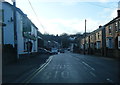
2
Corner of Halls Road and Bryngwyn Road, Newbridge
The sign shows that Halls Road on the left leads to Tunnel Terrace.
Image: © Jaggery
Taken: 18 Sep 2015
0.03 miles
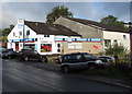
3
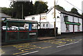
Bryngwyn Road pub and bus shelter, Newbridge
The bus stop is handily placed for the Red Lion pub on the right.
Image: © Jaggery
Taken: 18 Sep 2015
0.03 miles
4
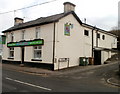
Red Lion, Newbridge
Pub on Bryngwyn Road, on the corner of a lane leading to Tunnel Terrace and the track of a dismantled railway.
Image: © Jaggery
Taken: 24 Jan 2011
0.03 miles
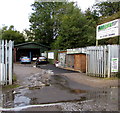
5
Ace Performance Cars garage in Newbridge
Located in The Garage, High Street, Newbridge. Various signs show Bosch Car Service,
Vauxhall Centre, tyres, shock absorbers, exhausts, MOT and air con (air conditioning).
Image: © Jaggery
Taken: 18 Sep 2015
0.04 miles
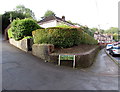
6
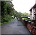
Side road south of Bryngwyn Road, Newbridge
Opposite Halls Road, http://www.geograph.org.uk/photo/4670006 this side road give access to the backs of numbers 1-13 Bryngwyn Road.
Image: © Jaggery
Taken: 18 Sep 2015
0.04 miles
7
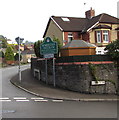
Western boundary of Newbridge
The boundary sign is on the corner of New Bryngwyn Road and Bryngwyn Road.
In 2015 part of the county borough of Caerphilly, Newbridge was historically part of Monmouthshire.
The Welsh name for this town is incorrectly shown on some maps as Cefn Bychan.
The sign shows that this Newbridge's Welsh name is Trecelyn, which literally means town of holly (trees).
Image: © Jaggery
Taken: 18 Sep 2015
0.04 miles
8
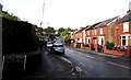
West along Bryngwyn Road, Newbridge
From the corner of Halls Road near the western edge of Newbridge.
Image: © Jaggery
Taken: 18 Sep 2015
0.05 miles
9
Jacs Tyres, Newbridge
Sellers of part-worn and new tyres, located in the Old Blacksmiths Yard, below High Street.
Image: © Jaggery
Taken: 18 Sep 2015
0.05 miles
10
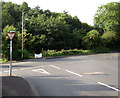
Ildiwch/Give Way sign in Newbridge
The bilingual (Welsh/English) sign is at the southern end of New Bryngwyn Road, at the Bryngwyn Road junction.
Image: © Jaggery
Taken: 18 Sep 2015
0.05 miles