IMAGES TAKEN NEAR TO
Pennar Street, NEWPORT, NP11 4GB
Introduction
This page details the photographs taken nearby to Pennar Street, NP11 4GB by members of the Geograph project.
The Geograph project started in 2005 with the aim of publishing, organising and preserving representative images for every square kilometre of Great Britain, Ireland and the Isle of Man.

There are currently over 7.5m images from over14,400 individuals and you can help contribute to the project by visiting https://www.geograph.org.uk
Image Map
Images are licensed for reuse under creativecommons.org/licenses/by-sa/2.0
Notes
- Clicking on the map will re-center to the selected point.
- The higher the marker number, the further away the image location is from the centre of the postcode.
Image Listing (267 Images Found)
Images are licensed for reuse under creativecommons.org/licenses/by-sa/2.0
Image
Details
Distance
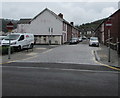
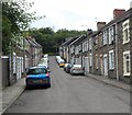
1
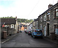
Pennar Street, Newbridge
Descending from Tramroadside to Panteg Terrace and Meredith Terrace.
Image: © Jaggery
Taken: 18 Sep 2015
0.03 miles
2
Meredith Terrace, Newbridge
From the corner of High Street.
Image: © Jaggery
Taken: 15 Dec 2016
0.03 miles
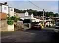
3
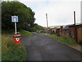
No through road sign, Tramroadside, Newbridge
Metal barriers across Tramroadside out of shot ahead make this a dead end route for motor vehicles.
Walkers and cyclists can pass through the barriers to reach High Street. The red bin is for dog waste.
The left turn is into Penrhiwbicca. http://www.geograph.org.uk/photo/4668443
Image: © Jaggery
Taken: 18 Sep 2015
0.03 miles
4
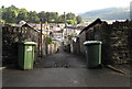
Lane descends towards Meredith Terrace, Newbridge
The lane is between the backs of Pennar Street houses on the left and the backs of Hill Street houses on the right.
Image: © Jaggery
Taken: 18 Sep 2015
0.04 miles
5
Meredith Terrace in Newbridge
Meredith Terrace No Entry signs face High Street.
Image: © Jaggery
Taken: 30 Jul 2019
0.04 miles
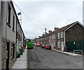
6
Patched-up side road surface, Newbridge
The road descends from Beynon Street past the backs of Hill Street houses.
Image: © Jaggery
Taken: 18 Sep 2015
0.05 miles
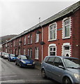
7
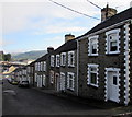
East side of Hill Street, Newbridge
Row of houses extending for 95 metres (about 310ft) from Beynon Street to Torlais Street.
Image: © Jaggery
Taken: 18 Sep 2015
0.05 miles
8
Blaen-Blodau Street, Newbridge
Viewed from the eastern end of the street, opposite the street name sign in front of an electricity substation.
Image: © Jaggery
Taken: 8 Aug 2012
0.05 miles
9
Hill Street, Newbridge
Viewed from the corner of Torlais Street.
Image: © Jaggery
Taken: 8 Aug 2012
0.05 miles
10
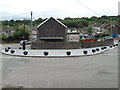
Solid black spheres line a bend in the road, Newbridge
Viewed from the corner of West View and Main Street. The spheres have replaced thin black and white posts, which perhaps were knocked over too easily. These spheres appear to be more robust.
Image: © Jaggery
Taken: 8 Aug 2012
0.05 miles