IMAGES TAKEN NEAR TO
Panteg Terrace, NEWPORT, NP11 4GA
Introduction
This page details the photographs taken nearby to Panteg Terrace, NP11 4GA by members of the Geograph project.
The Geograph project started in 2005 with the aim of publishing, organising and preserving representative images for every square kilometre of Great Britain, Ireland and the Isle of Man.

There are currently over 7.5m images from over14,400 individuals and you can help contribute to the project by visiting https://www.geograph.org.uk
Image Map
Images are licensed for reuse under creativecommons.org/licenses/by-sa/2.0
Notes
- Clicking on the map will re-center to the selected point.
- The higher the marker number, the further away the image location is from the centre of the postcode.
Image Listing (254 Images Found)
Images are licensed for reuse under creativecommons.org/licenses/by-sa/2.0
Image
Details
Distance
1
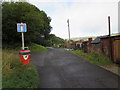
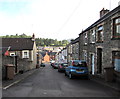
No through road sign, Tramroadside, Newbridge
Metal barriers across Tramroadside out of shot ahead make this a dead end route for motor vehicles.
Walkers and cyclists can pass through the barriers to reach High Street. The red bin is for dog waste.
The left turn is into Penrhiwbicca. http://www.geograph.org.uk/photo/4668443
Image: © Jaggery
Taken: 18 Sep 2015
0.03 miles
2
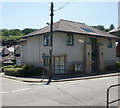
Newbridge Police Station
On the corner of High Street and West View.
Image: © Jaggery
Taken: 23 Jun 2010
0.04 miles
3
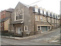
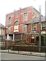
Newbridge : former Zion Chapel converted to flats
The external shell of the former Zion Chapel, on the corner of High Street and Tyllwyd Place, was retained on conversion to flats. The most obvious external additions are the row of seven dormer windows, and the wide metal door near the corner.
Image: © Jaggery
Taken: 24 Jan 2011
0.04 miles
4
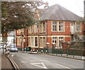
Celynen Collieries Workmen's Institute, Newbridge
Grade II listed building on the corner of High Street and Meredith Terrace.
The date stone shows 1907. It was listed for its special interest as a purpose-built colliery workers' institute. It served the miners of Celynen North and Celynen South pits.
The Memorial Hall, http://www.geograph.org.uk/photo/2244213 also listed, is set back from the road, alongside the Institute.
Image: © Jaggery
Taken: 24 Jan 2011
0.04 miles
5
Celynen Collieries Workmen's Memorial Hall, Newbridge
Dating from 1924, this Grade II listed building is adjacent to the Institute,
http://www.geograph.org.uk/photo/2244197 also a listed building.
Image: © Jaggery
Taken: 24 Jan 2011
0.04 miles
6
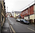
Tyllwyd Place, Newbridge
On the south side of High Street.
Image: © Jaggery
Taken: 15 Dec 2016
0.04 miles
7
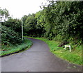
Penrhiwbicca, Newbridge
Minor road heading south from Tramroadside.
Image: © Jaggery
Taken: 18 Sep 2015
0.04 miles
8
Tyllwyd Place, Newbridge
On the south side of High Street.
Image: © Jaggery
Taken: 18 Sep 2015
0.04 miles
9
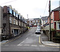
Pennar Street, Newbridge
Descending from Tramroadside to Panteg Terrace and Meredith Terrace.
Image: © Jaggery
Taken: 18 Sep 2015
0.05 miles
10
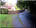
Metal barrier across Tramroadside, Newbridge
This is as far as motor vehicles can go. Walkers and cyclists can pass through the narrow gap on the right.
The arm on the wooden signpost on the left depicts two horses pulling a carriage, indicating a bridleway, but there is no side gate here. I concluded that the signpost must have been installed before the barrier was here.
Image: © Jaggery
Taken: 18 Sep 2015
0.05 miles