1
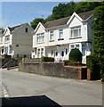
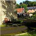
Tynewydd Terrace, Newbridge
Houses viewed from the corner of Cwrt Tynewydd.
Image: © Jaggery
Taken: 23 Jun 2010
0.02 miles
2
Owen family bench in St Paul's churchyard, Newbridge
Facing the west side of this http://www.geograph.org.uk/photo/4664730 church, the bench is dedicated to the memory of three deceased members of the Owen family.
Image: © Jaggery
Taken: 18 Sep 2015
0.02 miles
3
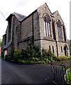
West side of St Paul's Church, Newbridge
Located on the north side of High Street, the Parish Church of
St Paul Newbridge is part of the Church in Wales Diocese of Monmouth.
The church building was Grade II listed in 1999.
Image: © Jaggery
Taken: 18 Sep 2015
0.02 miles
4
North side of St Paul's Church, Newbridge
Located on the north side of High Street, the Parish Church of
St Paul Newbridge is part of the Church in Wales Diocese of Monmouth.
The church building was Grade II listed in 1999.
Image: © Jaggery
Taken: 18 Sep 2015
0.02 miles
5
Rusty-roofed church hall, Newbridge
On the north side of St Paul's Church. http://www.geograph.org.uk/photo/4664730
Image: © Jaggery
Taken: 18 Sep 2015
0.02 miles
6
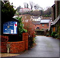
Parish Church of St Paul Newbridge nameboard
At the entrance to this http://www.geograph.org.uk/photo/4664730 church, the nameboard facing High Street shows that the church is part of the Church in Wales Diocese of Monmouth.
Image: © Jaggery
Taken: 15 Dec 2016
0.02 miles
7
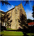
Back of St Paul's Church, Newbridge
The Parish Church of St Paul Newbridge is part of the Church in Wales Diocese of Monmouth.
Viewed from near the NE corner of the church which faces High Street.
The church building was Grade II listed in 1999.
Image: © Jaggery
Taken: 18 Sep 2015
0.03 miles
8
Humps for 330 yards sign, Newbridge
Traffic calming measures on High Street.
Image: © Jaggery
Taken: 18 Sep 2015
0.03 miles
9
East side of St Paul's Church, Newbridge
Located on the north side of High Street, the Parish Church of
St Paul Newbridge is part of the Church in Wales Diocese of Monmouth.
The church building was Grade II listed in 1999.
The rusty church hall roof is in the background.
Image: © Jaggery
Taken: 18 Sep 2015
0.03 miles
10
Churchyard benches, Newbridge
On the east side of St Paul's Church. http://www.geograph.org.uk/photo/4664748 The rusty roof is on the church hall. http://www.geograph.org.uk/photo/4664773
Image: © Jaggery
Taken: 18 Sep 2015
0.03 miles


