1
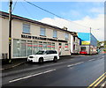
Marsh Villas, Newbridge
Row of houses on the north side of High Street.
Image: © Jaggery
Taken: 18 Sep 2015
0.01 miles
2
High Street west of Tramroadside, Newbridge
Viewed from the Tramroadside junction. Though there are a few shops and other
businesses elsewhere in this High Street, the street is mainly residential.
Image: © Jaggery
Taken: 18 Sep 2015
0.01 miles
3
Black and white traffic cones on the north side of High Street, Newbridge
The cones have been placed here in preparation for the passage of a funeral cortege.
Image: © Jaggery
Taken: 18 Sep 2015
0.02 miles
4
One Stop store, High Street, Newbridge
Open every day from 7am till 11pm, the High Street store sells groceries,
chilled & frozen food, soft drinks, beers, wines, newspapers, magazines, stationery etc.
Image: © Jaggery
Taken: 18 Sep 2015
0.02 miles
5
Ordnance Survey Flush Bracket (S9953)
This OS Flush Bracket can be found on the old garage building, south side of High Street. It marks a point 132.544m above mean sea level.
Image: © Adrian Dust
Taken: 11 May 2019
0.02 miles
6
Ellis Williams Funeral Directors, Newbridge
Viewed across High Street.
Image: © Jaggery
Taken: 18 Sep 2015
0.03 miles
7
Victorian postbox in a High Street wall, Newbridge
In the wall between the two cars here. http://www.geograph.org.uk/photo/4664410
Image: © Jaggery
Taken: 18 Sep 2015
0.03 miles
8
Metal frame below High Street, Newbridge
Supporting the rear of the One Stop site. http://www.geograph.org.uk/photo/4664430
Image: © Jaggery
Taken: 18 Sep 2015
0.03 miles
9
Charlotteville, Newbridge
A dormer bungalow on the south side of High Street, adjacent to the Tramroadside turning.
Image: © Jaggery
Taken: 24 Jan 2011
0.04 miles
10
Hovis lorry and Salvation Army donations bin, High Street, Newbridge
On the west side of a One Stop store. http://www.geograph.org.uk/photo/4664430 The green bin is for donations of good quality clothes and shoes
to the Salvation Army. Proceeds from the sale of donated items help needy people in the local community.
Image: © Jaggery
Taken: 18 Sep 2015
0.04 miles


