IMAGES TAKEN NEAR TO
High Street, NEWPORT, NP11 4FJ
Introduction
This page details the photographs taken nearby to High Street, NP11 4FJ by members of the Geograph project.
The Geograph project started in 2005 with the aim of publishing, organising and preserving representative images for every square kilometre of Great Britain, Ireland and the Isle of Man.

There are currently over 7.5m images from over14,400 individuals and you can help contribute to the project by visiting https://www.geograph.org.uk
Image Map
Images are licensed for reuse under creativecommons.org/licenses/by-sa/2.0
Notes
- Clicking on the map will re-center to the selected point.
- The higher the marker number, the further away the image location is from the centre of the postcode.
Image Listing (273 Images Found)
Images are licensed for reuse under creativecommons.org/licenses/by-sa/2.0
Image
Details
Distance
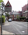
1
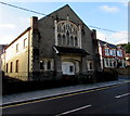
Zion House, Newbridge
The former chapel on the corner of High Street and Tyllwyd Place has been converted to flats.
http://www.geograph.org.uk/photo/2244162 to a side view.
Image: © Jaggery
Taken: 18 Sep 2015
0.01 miles
2
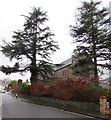
Evergreen trees in St Paul's churchyard, Newbridge
Viewed across High Street in mid December 2016 when deciduous trees are leafless.
Image: © Jaggery
Taken: 15 Dec 2016
0.02 miles
3
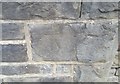
Ordnance Survey Cut Mark
This OS cut mark can be found on the west face of the Zion Chapel. It marks a point 116.714m above mean sea level.
Image: © Adrian Dust
Taken: 11 May 2019
0.02 miles
4
Parish Church of St Paul Newbridge nameboard
At the entrance to this http://www.geograph.org.uk/photo/4664730 church, the nameboard facing High Street shows that the church is part of the Church in Wales Diocese of Monmouth.
Image: © Jaggery
Taken: 15 Dec 2016
0.02 miles
5
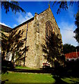
East side of St Paul's Church, Newbridge
Located on the north side of High Street, the Parish Church of
St Paul Newbridge is part of the Church in Wales Diocese of Monmouth.
The church building was Grade II listed in 1999.
The rusty church hall roof is in the background.
Image: © Jaggery
Taken: 18 Sep 2015
0.02 miles
6
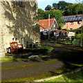
Churchyard benches, Newbridge
On the east side of St Paul's Church. http://www.geograph.org.uk/photo/4664748 The rusty roof is on the church hall. http://www.geograph.org.uk/photo/4664773
Image: © Jaggery
Taken: 18 Sep 2015
0.02 miles
7
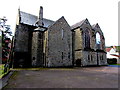
Back of St Paul's Church, Newbridge
The Parish Church of St Paul Newbridge is part of the Church in Wales Diocese of Monmouth.
Viewed from near the NE corner of the church which faces High Street.
The church building was Grade II listed in 1999.
Image: © Jaggery
Taken: 18 Sep 2015
0.02 miles
8
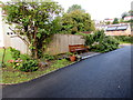
Owen family bench in St Paul's churchyard, Newbridge
Facing the west side of this http://www.geograph.org.uk/photo/4664730 church, the bench is dedicated to the memory of three deceased members of the Owen family.
Image: © Jaggery
Taken: 18 Sep 2015
0.02 miles
9
Humps for 330 yards sign, Newbridge
Traffic calming measures on High Street.
Image: © Jaggery
Taken: 18 Sep 2015
0.02 miles
10
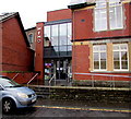
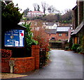
Meredith Terrace entrance to the Memo, Newbridge
The Memo is Newbridge Memorial Hall.
Image: © Jaggery
Taken: 15 Dec 2016
0.03 miles