IMAGES TAKEN NEAR TO
Celynen Close, NP11 4AT
Introduction
This page details the photographs taken nearby to Celynen Close, NP11 4AT by members of the Geograph project.
The Geograph project started in 2005 with the aim of publishing, organising and preserving representative images for every square kilometre of Great Britain, Ireland and the Isle of Man.

There are currently over 7.5m images from over14,400 individuals and you can help contribute to the project by visiting https://www.geograph.org.uk
Image Map
Images are licensed for reuse under creativecommons.org/licenses/by-sa/2.0
Notes
- Clicking on the map will re-center to the selected point.
- The higher the marker number, the further away the image location is from the centre of the postcode.
Image Listing (243 Images Found)
Images are licensed for reuse under creativecommons.org/licenses/by-sa/2.0
Image
Details
Distance
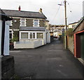
1
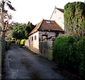
Tŷ Cae'r Eglwys, Newbridge
House at the western end of Thorne Avenue.
Image: © Jaggery
Taken: 14 Jan 2017
0.04 miles
2
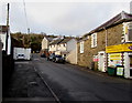
Ashfield Road, Newbridge
Looking NW along Ashfield Road from the Greenfield junction. Greenfield Stores http://www.geograph.org.uk/photo/5254078 are on the right.
Image: © Jaggery
Taken: 14 Jan 2017
0.05 miles
3
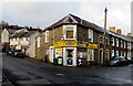
Greenfield Stores, Newbridge
Premier Express convenience store at number 1 Greenfield, on the corner of Ashfield Road.
Image: © Jaggery
Taken: 14 Jan 2017
0.05 miles
4
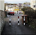
Three posts across the NW end of Yew Tree Road, Newbridge
No access for motor vehicles to or from Ashfield Road. Greenfield Stores http://www.geograph.org.uk/photo/5254078 are in the background.
Image: © Jaggery
Taken: 14 Jan 2017
0.05 miles
5
Route for walkers only, Yew Tree Road, Newbridge
Viewed from Ashfield Road. Posts block vehicular access to Yew Tree Road
and a red-edged circular sign indicates No Cycling.
Image: © Jaggery
Taken: 14 Jan 2017
0.05 miles
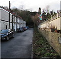
6
Greenfield Avenue, Newbridge
Short row of houses between Yew Tree Road and Church Road.
Image: © Jaggery
Taken: 14 Jan 2017
0.05 miles
7
No parking in Ashfield Road, Newbridge
Double yellow lines on both sides indicate no parking at any time.
Image: © Jaggery
Taken: 14 Jan 2017
0.06 miles
9
Yew Tree Road junction, Newbridge
Ahead along Yew Tree Road for Ashfield Road or left for Greenfield Avenue. http://www.geograph.org.uk/photo/5263594
Image: © Jaggery
Taken: 14 Jan 2017
0.06 miles
10
23-30 Alexandra Place, Newbridge
A dead street aligned east-west, at right angles to the main course of Alexandra Place.
Image: © Jaggery
Taken: 14 Jan 2017
0.06 miles