1
Bridge over the A 472 near Pentwyn-mawr
Image: © Ruth Sharville
Taken: 25 Jun 2013
0.04 miles
2
The A472 looking east
This section of the A472 links the Ebbw Valley with the Sirhowy Valley.
Taken from a layby and looking towards the highest point on this section of the road with a minor road overhead on a bridge.
Image: © Robin Drayton
Taken: 20 Aug 2009
0.06 miles
3
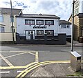
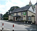
Cwtchers, High Street, Pentwynmawr
Family-owned village pub opposite Fox Avenue viewed in May 2022.
Pentwynmawr Sports Bar https://www.geograph.org.uk/photo/2017385 was here in 2010.
Image: © Jaggery
Taken: 5 May 2022
0.07 miles
4
Bus stop sign, High Street, Pentwynmawr
Alongside a stop for buses to Newbridge, Risca, Newport etc.
Image: © Jaggery
Taken: 5 May 2022
0.07 miles
5
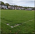
Football pitch, Pentwynmawr
Part of Pentwynmawr Recreation Ground.
Image: © Jaggery
Taken: 5 May 2022
0.07 miles
6
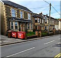
Two red Biffa wheelie bins, High Street, Pentwynmawr
The bin near the road is for mixed recyclables.
The other Biffa bin is for general waste.
Image: © Jaggery
Taken: 5 May 2022
0.08 miles
7
The A472 looking east, from the bridge near Pentwyn-mawr
Image: © Ruth Sharville
Taken: 25 Jun 2013
0.08 miles
8
The A472 looking west, from the bridge near Pentwyn-mawr
Image: © Ruth Sharville
Taken: 25 Jun 2013
0.08 miles
9
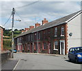
Fox Avenue, Pentwynmawr
Viewed from High Street.
Whatever it was that made this street an avenue whereas a few metres away, Station Street http://www.geograph.org.uk/photo/2017277 is a street, was too subtle to be apparent to this observer.
Image: © Jaggery
Taken: 16 Aug 2010
0.08 miles
10
Three Horseshoes, Pentwynmawr
Pub on the south side of High Street. A green Three Horseshoes sign appears in this view to be attached to a bus shelter, but it is actually in the corner of the car park, strategically placed.
Image: © Jaggery
Taken: 16 Aug 2010
0.08 miles


