IMAGES TAKEN NEAR TO
North Road, NEWPORT, NP11 4AF
Introduction
This page details the photographs taken nearby to North Road, NP11 4AF by members of the Geograph project.
The Geograph project started in 2005 with the aim of publishing, organising and preserving representative images for every square kilometre of Great Britain, Ireland and the Isle of Man.

There are currently over 7.5m images from over14,400 individuals and you can help contribute to the project by visiting https://www.geograph.org.uk
Image Map
Images are licensed for reuse under creativecommons.org/licenses/by-sa/2.0
Notes
- Clicking on the map will re-center to the selected point.
- The higher the marker number, the further away the image location is from the centre of the postcode.
Image Listing (28 Images Found)
Images are licensed for reuse under creativecommons.org/licenses/by-sa/2.0
Image
Details
Distance
1
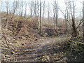
Track through the woods, Newbridge
The track is between the Ebbw Valley railway and the Ebbw River. Access from North Road is via an underpass. http://www.geograph.org.uk/photo/2297316
Image: © Jaggery
Taken: 17 Feb 2011
0.03 miles
2
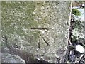
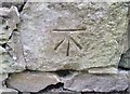
Ordnance Survey Cut Mark
This OS cut mark can be found on the south face of the subway. It marks a point 109.984m above mean sea level.
Image: © Adrian Dust
Taken: 11 May 2019
0.03 miles
3
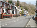
Newbridge : houses near the northern end of North Road
The view north along North Road. The Crumlin border http://www.geograph.org.uk/photo/2297382 is a short distance ahead.
Image: © Jaggery
Taken: 17 Feb 2011
0.07 miles
4
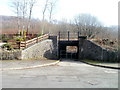
Under the railway, North Road, Newbridge
An underpass leads from North Road under the Ebbw Valley railway into woodland. http://www.geograph.org.uk/photo/2297345
Metal barriers prevent vehicular access, so the 7 feet 6 inch headroom painted on the bridge is likely to be of immediate interest only to visiting basketball players...
Image: © Jaggery
Taken: 17 Feb 2011
0.07 miles
5

Steam at Celynen North Colliery ? 1969
Peckett locomotive 'Sir John Wyndham Beynon' (works no.1565, built 1920) hauls a load of wagons away from the screens on a sunny November day.
Steam persisted at collieries well after it had ceased on the main line network because of the availability of cheap fuel.
Image: © Alan Murray-Rust
Taken: 25 Nov 1969
0.07 miles
6
Ordnance Survey Cut Mark
This OS cut mark can be found on the wall SE side of North Road. It marks a point 109.167m above mean sea level.
Image: © Adrian Dust
Taken: 11 May 2019
0.07 miles
7
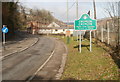
Southern boundary of Crumlin
Viewed along North Road from the northern edge of Newbridge.
Crumlin, population about 6,000, is a town in Caerphilly County Borough.
Image: © Jaggery
Taken: 17 Feb 2011
0.09 miles
8
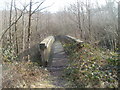
Wooden bridge across the Ebbw River, Newbridge
The bridge is about 60 metres from an underpass http://www.geograph.org.uk/photo/2297316 from North Road to woodland.
Image: © Jaggery
Taken: 17 Feb 2011
0.09 miles
9
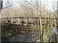
Side view of wooden bridge above Ebbw River, Newbridge
The bridge crosses the Ebbw about 60 metres into woodland, access via an underpass http://www.geograph.org.uk/photo/2297316 from North Road.
Image: © Jaggery
Taken: 17 Feb 2011
0.09 miles
10
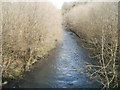
Ebbw River viewed from a wooden bridge, Newbridge
Viewed from this bridge http://www.geograph.org.uk/photo/2297359 to the east of North Road.
Image: © Jaggery
Taken: 17 Feb 2011
0.09 miles