IMAGES TAKEN NEAR TO
Navigation Industrial Estate, NEWPORT, NP11 3PA
Introduction
This page details the photographs taken nearby to Navigation Industrial Estate, NP11 3PA by members of the Geograph project.
The Geograph project started in 2005 with the aim of publishing, organising and preserving representative images for every square kilometre of Great Britain, Ireland and the Isle of Man.

There are currently over 7.5m images from over14,400 individuals and you can help contribute to the project by visiting https://www.geograph.org.uk
Image Map
Images are licensed for reuse under creativecommons.org/licenses/by-sa/2.0
Notes
- Clicking on the map will re-center to the selected point.
- The higher the marker number, the further away the image location is from the centre of the postcode.
Image Listing (142 Images Found)
Images are licensed for reuse under creativecommons.org/licenses/by-sa/2.0
Image
Details
Distance
1
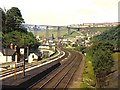
Crumlin viaduct from Celynen North
This was the highest railway viaduct in the British Isles throughout its working life, crossing the Ebbw valley at a height of 200 feet. It was always expensive to maintain, because of its height and the fierce winds of the valley. The last passenger train from Pontypool to Treherbert crossed it on 13 June 1964. In spite of being scheduled, it was dismantled in 1967 because of its poor condition and houses in the valley below.
Celynen North halt served the adjacent colliery.
Image: © Richard Green
Taken: 4 Jun 1963
0.02 miles
2
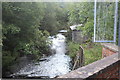
River Ebbw below Crumlin Navigation Colliery
Looking downstream the river has just emerged form a long culvert Image under the former colliery site. The spiked metal railings protect a pipeline just out of shot.
Image: © M J Roscoe
Taken: 16 Sep 2017
0.02 miles
3
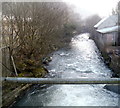
Coffer dam, River Ebbw, Crumlin
A temporary dam across half of the river to enable repairs to the base of the central pier (out of picture to the bottom right) of the railway bridge.
Image: © M J Roscoe
Taken: 18 Aug 2016
0.02 miles
4
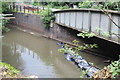
River Ebbw, Crumlin
Looking downstream along the Ebbw, which has just emerged from an underground conduit about 300 metres long, on the east side of the former Navigation Colliery.
Image: © Jaggery
Taken: 17 Feb 2011
0.02 miles
5
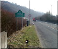
NE boundary of Crumlin
The A467 reaches Crumlin, a town in Caerphilly County Borough. Crumlin's population was 5,724 at the time of the 2001 UK Census.
Image: © Jaggery
Taken: 17 Feb 2011
0.02 miles
6
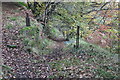
Path along hillside, near Crumlin
Start of footpath from bridleway, left Image; part of Llanerch-Isaf Woodland Site of Importance for Nature Conservation.
Image: © M J Roscoe
Taken: 30 Oct 2016
0.02 miles
7
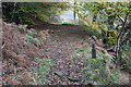
Byway up to Ebbw Valley Walk
Restricted byway, continuation of the byway Image up from Crumlin. The start of another path Image can be seen at bottom right; part of Llanerch-Isaf Woodland Site of Importance for Nature Conservation.
Image: © M J Roscoe
Taken: 30 Oct 2016
0.03 miles
8

Sofa Sofa
Looking towards the A467 at Crumlin from the furniture retailer's showroom.
Image: © Jonathan Billinger
Taken: 17 Nov 2021
0.03 miles
9
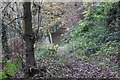
Byway down hillside to Crumlin
Restricted byway, above River Ebbw, down to bottom of Load of Hay Lane Image; part of Llanerch-Isaf Woodland Site of Importance for Nature Conservation.
Image: © M J Roscoe
Taken: 30 Oct 2016
0.03 miles
10
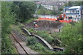
Site preparation at side of A467, Crumlin
The embankment supporting the A467 has been removed on the east bank of the River Ebbw in preparation for replacing the railway bridge Image with a wider deck able to carry two lines.
Image: © M J Roscoe
Taken: 16 Aug 2020
0.04 miles