IMAGES TAKEN NEAR TO
Trinant Terrace, NEWPORT, NP11 3JJ
Introduction
This page details the photographs taken nearby to Trinant Terrace, NP11 3JJ by members of the Geograph project.
The Geograph project started in 2005 with the aim of publishing, organising and preserving representative images for every square kilometre of Great Britain, Ireland and the Isle of Man.

There are currently over 7.5m images from over14,400 individuals and you can help contribute to the project by visiting https://www.geograph.org.uk
Image Map
Images are licensed for reuse under creativecommons.org/licenses/by-sa/2.0
Notes
- Clicking on the map will re-center to the selected point.
- The higher the marker number, the further away the image location is from the centre of the postcode.
Image Listing (67 Images Found)
Images are licensed for reuse under creativecommons.org/licenses/by-sa/2.0
Image
Details
Distance
1
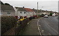
Trinant Terrace semis, Pentwyn
Semi-detached houses on the east side of Trinant Terrace.
Image: © Jaggery
Taken: 19 Dec 2016
0.01 miles
2
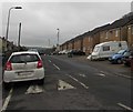
Trinant Terrace speed bump, Pentwyn
One of several speed bumps on the approach to Trinant Primary School.
A 20mph speed limit is in force here.
Image: © Jaggery
Taken: 19 Dec 2016
0.02 miles
3
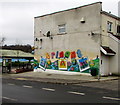
Trinant mural
On the side wall of this shop, http://www.geograph.org.uk/photo/5233789 viewed in December 2016.
The mural was not here in an October 2009 Google Earth Street View.
Image: © Jaggery
Taken: 19 Dec 2016
0.04 miles
4
BT phonebox, Trinant Terrace, Pentwyn
Located opposite Conway Road, at the edge of Trinant Stores.
Image: © Jaggery
Taken: 19 Dec 2016
0.04 miles
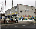
6
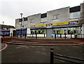
Trinant Stores, Pentwyn
A Premier convenience store set back from Trinant Terrace, opposite Conway Road.
Image: © Jaggery
Taken: 19 Dec 2016
0.05 miles
7
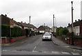
Western end of Conway Road, Pentwyn
Looking east along Conway Road from Trinant Terrace.
The warning sign on the left is on the approach to Trinant Primary School.
Image: © Jaggery
Taken: 19 Dec 2016
0.05 miles
8
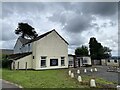
Three benches near Trinant Clinic, Pentwyn
The Trinant Clinic nameboard is on the wall on the right.
Image: © Jaggery
Taken: 19 Dec 2016
0.06 miles
9
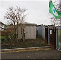
Electricity substation at the entrance to Trinant Primary School, Pentwyn
On the left here, http://www.geograph.org.uk/photo/5229806 set back 25 metres from Conway Road.
The Western Power Distribution electricity substation identifier is CONWAY RD TRINANT S/S 551169.
Image: © Jaggery
Taken: 19 Dec 2016
0.06 miles
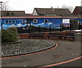
10
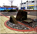
Boulder feature in a corner of the shopping centre, Pentwyn
On the west side of Trinant Terrace. Trinant Stores http://www.geograph.org.uk/photo/5233789 are in the background.
Image: © Jaggery
Taken: 19 Dec 2016
0.06 miles