IMAGES TAKEN NEAR TO
Brynffynnon, NP11 3EQ
Introduction
This page details the photographs taken nearby to Brynffynnon, NP11 3EQ by members of the Geograph project.
The Geograph project started in 2005 with the aim of publishing, organising and preserving representative images for every square kilometre of Great Britain, Ireland and the Isle of Man.

There are currently over 7.5m images from over14,400 individuals and you can help contribute to the project by visiting https://www.geograph.org.uk
Image Map
Images are licensed for reuse under creativecommons.org/licenses/by-sa/2.0
Notes
- Clicking on the map will re-center to the selected point.
- The higher the marker number, the further away the image location is from the centre of the postcode.
Image Listing (35 Images Found)
Images are licensed for reuse under creativecommons.org/licenses/by-sa/2.0
Image
Details
Distance
1
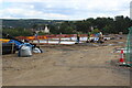
Construction site, Ton-y-Felin Farm Lane
Laying concrete on a building site for 60 affordable homes for Pobl Housing Association.
Image: © M J Roscoe
Taken: 5 Aug 2022
0.02 miles
2
Building site, Ton-y-Felin Farm Lane
A housing development by Pobl Housing Association of 60 affordable homes on a valley-side field next to Kendon Road.
Image: © M J Roscoe
Taken: 5 Aug 2022
0.02 miles
3
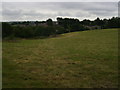
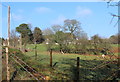
Meadow, Lower Ton-y-Felin
Taken from stile; field footpath little used, no clear track.
Image: © M J Roscoe
Taken: 15 Jul 2015
0.03 miles
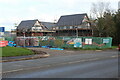
4
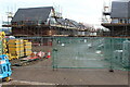
Partly built houses, Ton-y-Felin Farm Lane
Housing estate for Pobl Housing Association; for similar earlier view - Image
Image: © M J Roscoe
Taken: 30 Oct 2022
0.04 miles
5
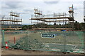
Scaffolding, building site, Ton-y-felin Farm Lane
Part of a housing development of 60 affordable homes for Pobl Housing Association.
Image: © M J Roscoe
Taken: 28 Aug 2022
0.05 miles
6
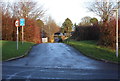
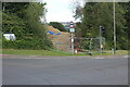
Minor road to Trinant from Parkway, Croespenmaen
The beginning of a road to Trinant which becomes a rough track shortly after passing Lower Ton-y-felin Farm, seen in the background. The blue sign says, 'Unsuitable for heavy goods vehicles', and is repeated underneath in Welsh.
Image: © M J Roscoe
Taken: 21 Dec 2015
0.05 miles
7
Junction of Ton-y-Felin Farm Lane & Parkway
The houses are being built for Pobl Housing Association.
Image: © M J Roscoe
Taken: 30 Oct 2022
0.06 miles
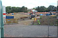
8
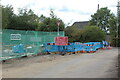
Roadworks at end of Ton-y-Felin Farm Lane
Excavations at junction of Farm Lane and Parkway to connect services to a new housing estate.
Image: © M J Roscoe
Taken: 28 Aug 2022
0.06 miles
9
Lower Ton-y-Felin, Croespenmaen
A field footpath runs along the left of the wire fence
Image: © M J Roscoe
Taken: 6 Jan 2016
0.06 miles
10
Route for walkway into new housing development
The path will go from a light-controlled pedestrian crossing on the Kendon Road, B4251, near its junction with Parkway to the new housing estate Image
Image: © M J Roscoe
Taken: 5 Aug 2022
0.06 miles