IMAGES TAKEN NEAR TO
Rush Drive, NEWPORT, NP11 3EJ
Introduction
This page details the photographs taken nearby to Rush Drive, NP11 3EJ by members of the Geograph project.
The Geograph project started in 2005 with the aim of publishing, organising and preserving representative images for every square kilometre of Great Britain, Ireland and the Isle of Man.

There are currently over 7.5m images from over14,400 individuals and you can help contribute to the project by visiting https://www.geograph.org.uk
Image Map
Images are licensed for reuse under creativecommons.org/licenses/by-sa/2.0
Notes
- Clicking on the map will re-center to the selected point.
- The higher the marker number, the further away the image location is from the centre of the postcode.
Image Listing (71 Images Found)
Images are licensed for reuse under creativecommons.org/licenses/by-sa/2.0
Image
Details
Distance
1
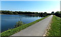
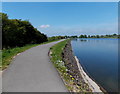
Embankment path at the southern edge of Pen-y-fan Pond
The embankment extends for nearly 350 metres along the southern edge of
the former canal feeder reservoir in what is now Pen-y-fan Country Park.
Image: © Jaggery
Taken: 18 May 2014
0.06 miles
2
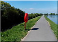
Lifebuoy at the edge of Pen-y-fan Pond
On the embankment extending for nearly 350 metres along the southern edge
of the former canal feeder reservoir in what is now Pen-y-fan Country Park.
Image: © Jaggery
Taken: 18 May 2014
0.06 miles
3
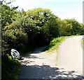
Path junction at the SE corner of Pen-y-fan Pond
Left fork for a descending path. Right fork for the pond embankment path. http://www.geograph.org.uk/photo/4326377
Image: © Jaggery
Taken: 18 May 2014
0.07 miles
4
Fly fishing in Pen-y-fan Pond
The former canal feeder reservoir (and surrounding land) has been a country park since 1976.
A nearby Islwyn & District Anglers notice http://www.geograph.org.uk/photo/4326281 shows that only fly fishing is allowed here.
Image: © Jaggery
Taken: 18 May 2014
0.09 miles
5
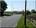
Parkway towards Pen-y-fan Industrial Estate
Looking south along Parkway from the edge of Pen-y-fan Country Park.
Image: © Jaggery
Taken: 18 May 2014
0.09 miles
6
West along the embankment path, Pen-y-fan Pond
The embankment http://www.geograph.org.uk/photo/4326377 extends for nearly 350 metres along the southern edge of the former canal feeder reservoir.
Image: © Jaggery
Taken: 18 May 2014
0.09 miles
7
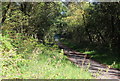
Old road below dam, Pen-y-fan Pond
This road, now closed to vehicular traffic, was part of the road from Croespenmaen to Aberbeeg in the middle of the twentieth century. It is part of the country park.
Image: © M J Roscoe
Taken: 26 Sep 2015
0.10 miles
8
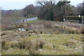
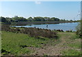
Pond off Parkway
Pond on marshy ground at junction of track with Parkway almost opposite Pen-y-fan Country Park (top left). Most of the pond dries up in summer.
Image: © M J Roscoe
Taken: 7 Apr 2018
0.11 miles
9

Pownd Pen y Fan Pond
Adeiladwyd Pownd Pen y Fan (Fe'i gelwid 'Pownd y Coedcae' gynt) yn 1794-6 er cyflenwi dwr i gamlas frysur Sir Fynwy mewn cyfnod pan ai llawer o drafnidiaeth ar hyd iddi.
Pen y Fan Pond (formerly known as Pownd y Coedcae) was built during 1794-6 to supply water to the then increasingly busy Monmouthshire Canal.
Image: © Alan Richards
Taken: 16 Feb 2014
0.11 miles
10
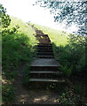
Steps up to Pen-y-fan Pond
From a road below the south side of the large pond http://www.geograph.org.uk/photo/4326329 in Pen-y-fan Country Park.
Image: © Jaggery
Taken: 18 May 2014
0.12 miles