IMAGES TAKEN NEAR TO
Albertina Road, NEWPORT, NP11 3DX
Introduction
This page details the photographs taken nearby to Albertina Road, NP11 3DX by members of the Geograph project.
The Geograph project started in 2005 with the aim of publishing, organising and preserving representative images for every square kilometre of Great Britain, Ireland and the Isle of Man.

There are currently over 7.5m images from over14,400 individuals and you can help contribute to the project by visiting https://www.geograph.org.uk
Image Map
Images are licensed for reuse under creativecommons.org/licenses/by-sa/2.0
Notes
- Clicking on the map will re-center to the selected point.
- The higher the marker number, the further away the image location is from the centre of the postcode.
Image Listing (51 Images Found)
Images are licensed for reuse under creativecommons.org/licenses/by-sa/2.0
Image
Details
Distance
1
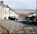
Western end of Parry Terrace, Treowen
Parry Terrace houses are on the left. On the right are the edges of houses on streets at right angle to Parry Terrace. The No Entry sign on the right is on the corner of Fflorens Road. http://www.geograph.org.uk/photo/2299755
Image: © Jaggery
Taken: 17 Feb 2011
0.02 miles
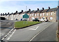
2
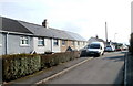
Albertina Road, Treowen
Viewed from the Parry Terrace end.
Image: © Jaggery
Taken: 17 Feb 2011
0.02 miles
3
Fflorens Road, Treowen
Viewed from Parry Terrace.
Image: © Jaggery
Taken: 17 Feb 2011
0.02 miles
4
Treowen Road, Treowen
View from Parry Terrace.
Image: © Jaggery
Taken: 17 Feb 2011
0.06 miles
5
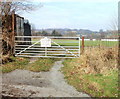
Entrance gate to Crumlin cricket ground
The entrance gate is 30 metres west of Albertina Road, at the western edge of residential Treowen.
At 220 metres (720 feet) above sea level, the cricket ground is about 85 metres (280 feet) higher than the average elevation of central Crumlin. Access is via Hillside. http://www.geograph.org.uk/photo/2297560
Image: © Jaggery
Taken: 17 Feb 2011
0.08 miles
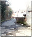
6
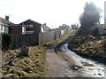
Track to Tir-hunt farm, Treowen
At the western edge of residential Treowen, a track runs past Albertina Road houses, heading for Tir-hunt Farm.
Image: © Jaggery
Taken: 17 Feb 2011
0.08 miles
7
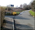
Road from Treowen to Oakdale
Viewed along Parry Terrace near the corner of Albertina Road. Ahead, beyond a sign advising "unsuitable for heavy goods vehicles", the road narrows as it heads away from residential Treowen into the countryside.
Image: © Jaggery
Taken: 17 Feb 2011
0.08 miles
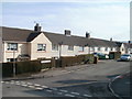
8
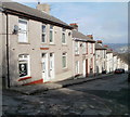
William Street, Treowen
Houses on the NE side of the street.
Image: © Jaggery
Taken: 17 Feb 2011
0.08 miles
9
Lane from Parry Terrace to William Street, Treowen
An unnamed lane connects Parry Terrace http://www.geograph.org.uk/photo/2299160 (behind the camera) with William Street. It runs along the eastern edge of Crumlin cricket ground. http://www.geograph.org.uk/photo/2299928
Image: © Jaggery
Taken: 17 Feb 2011
0.08 miles
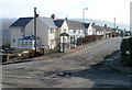
10
Parry Terrace, Treowen
At the top of the long climb up from Crumlin, the road (named Hillside) http://www.geograph.org.uk/photo/2297560 approaches the Treowen boundary, and Parry Terrace.
Image: © Jaggery
Taken: 17 Feb 2011
0.08 miles